IMAGES TAKEN NEAR TO
Portbury Common, BRISTOL, BS20 7TA
Introduction
This page details the photographs taken nearby to Portbury Common, BS20 7TA by members of the Geograph project.
The Geograph project started in 2005 with the aim of publishing, organising and preserving representative images for every square kilometre of Great Britain, Ireland and the Isle of Man.

There are currently over 7.5m images from over14,400 individuals and you can help contribute to the project by visiting https://www.geograph.org.uk
Image Map (Loading...)


Getting Data...Please wait
Leaflet Map data © OpenStreetMap
Images are licensed for reuse under creativecommons.org/licenses/by-sa/2.0
Notes
- Clicking on the map will re-center to the selected point.
- The higher the marker number, the further away the image location is from the centre of the postcode.
Image Listing (17 Images Found)
Images are licensed for reuse under creativecommons.org/licenses/by-sa/2.0
Image
Details
Distance
1

Portbury : Sheepway
Looking along a road with an Aggregate Industries lorry heading through.
Image: © Lewis Clarke
Taken: 2 Jun 2020
0.07 miles
2

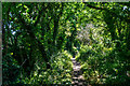
Portbury : Footpath
A footpath heading through the countryside.
Image: © Lewis Clarke
Taken: 2 Jun 2020
0.07 miles
3
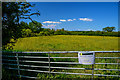
Portbury : Grassy Field & Gate
A sign promotes that the land is for sale.
Image: © Lewis Clarke
Taken: 2 Jun 2020
0.07 miles
4

Portbury : Footpath
A footpath heading off Sheepway.
Image: © Lewis Clarke
Taken: 2 Jun 2020
0.08 miles
5
Portbury : Footpath
Looking along a footpath.
Image: © Lewis Clarke
Taken: 2 Jun 2020
0.09 miles
6

Sheepway near to Portishead
New traffic calming measures, put in place since Streetview first covered this area.
Image: © Ruth Riddle
Taken: 10 Jul 2012
0.10 miles
7
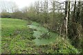
The Donkey Flood Zone
Sheepway, Portbury drainage rhyne Portishead Dock backwater containment to River Severn south on Northern Somerset Levels below the Gordano Valley peat and silt from spring geologic structure and marl restraint of seepage including some interbedded Permo-Triassic described sandstone marlstone affecting water resource store and transfers and various utility structures installed both Victorian and Recent and the Agricultural practices and Hedgerow forestry are an excellent horse and donkey reserve on clay but inclined to progressive flood water accumulation.
Image: © Michael Stagg
Taken: 1 Jan 2022
0.12 miles
8
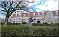
New housing on the outskirts of Portishead, North Somerset
Image: © Anthony O'Neil
Taken: 13 Apr 2009
0.14 miles
10
Portbury : Grassy Field
Looking across the fields of Portbury.
Image: © Lewis Clarke
Taken: 2 Jun 2020
0.15 miles