IMAGES TAKEN NEAR TO
Paper Mill Gardens, BRISTOL, BS20 7QY
Introduction
This page details the photographs taken nearby to Paper Mill Gardens, BS20 7QY by members of the Geograph project.
The Geograph project started in 2005 with the aim of publishing, organising and preserving representative images for every square kilometre of Great Britain, Ireland and the Isle of Man.

There are currently over 7.5m images from over14,400 individuals and you can help contribute to the project by visiting https://www.geograph.org.uk
Image Map (Loading...)


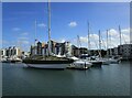
Getting Data...Please wait
Leaflet Map data © OpenStreetMap
Images are licensed for reuse under creativecommons.org/licenses/by-sa/2.0
Notes
- Clicking on the map will re-center to the selected point.
- The higher the marker number, the further away the image location is from the centre of the postcode.
Image Listing (118 Images Found)
Images are licensed for reuse under creativecommons.org/licenses/by-sa/2.0
Image
Details
Distance
1
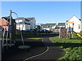
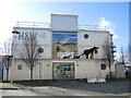
Paper Mill play space
As Portishead's old industries were pulled down and the land converted into residential expansion, the houses were separated by a play area. The old paper mill used to be close by near the docks: in the 1920s the Severn Kraft Mill was established to make specialist materials but had technical and legal problems right from the beginning. It lasted until the late 1930s and the site cleared.
Developer Taylor Wimpey built the houses and opened this play area in February, 2019. See Image] for the neighbour.
Image: © Neil Owen
Taken: 2 Jan 2023
0.05 miles
2
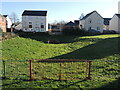
Balancing pond in Paper Mill Gardens
With Portishead's flat and marshy hinterland now occupied by housing, the estate has a balancing pond to cope with excessive rainfall and flooding. However, it lies next to a children's play area, and has an electricity substation opposite. See Image] for the play space.
Image: © Neil Owen
Taken: 2 Jan 2023
0.07 miles
3
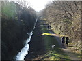
Walking the Portbury Ditch
Much of the land to the left (east) of the drainage was untouched for many years, with the water stopping expansion of the old docks. However, it is now part of the large expansion of the town once the old heavy industries departed. A new bridge has brought the homeowners to the marina and also created a popular walking route.
Image: © Neil Owen
Taken: 2 Jan 2023
0.07 miles
4
Hall and Woodhouse bar
A silvery metal block on the marina is a restaurant/bar. Outside on the balcony are some willowy creatures (badgers, perhaps?).
Image: © Neil Owen
Taken: 25 Feb 2022
0.11 miles
5
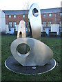
Part of 'Elemental'
One of the two sites spanning Phoenix Way is an atrwork by Bristol-based artist Matt Stein. Both are named 'Elemental' and are crafted from stainless steel; this group is named ' Axis, Cascade and Air' and is on the south side of the road. See Image] for the other piece.
Image: © Neil Owen
Taken: 2 Jan 2023
0.12 miles
6
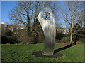
A tall element
Matt Stein was given a £25,000 commission in 2007 by developer Persimmon to create an artwork as the houses were being built. The piece was finally named 'Elemental' and comprises two parts; this 4m high stainless steel work is individually named 'Flare'. See Image] for the other side of the road and the rest of the sculptures.
Image: © Neil Owen
Taken: 2 Jan 2023
0.13 miles
7
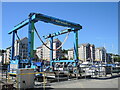
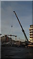
A crane for the craft
Portishead marina has a large crane for lifting vessels.
Image: © Neil Owen
Taken: 9 Jul 2022
0.13 miles
8
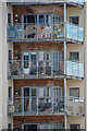
Portishead : Mizzen Court
Looking towards apartments at Mizzen Court.
Image: © Lewis Clarke
Taken: 2 Jun 2020
0.13 miles
9
Portishead Marina - Delivering a pontoon
Image: © Colin Park
Taken: 14 Dec 2016
0.14 miles