IMAGES TAKEN NEAR TO
Keel Avenue, BRISTOL, BS20 7PS
Introduction
This page details the photographs taken nearby to Keel Avenue, BS20 7PS by members of the Geograph project.
The Geograph project started in 2005 with the aim of publishing, organising and preserving representative images for every square kilometre of Great Britain, Ireland and the Isle of Man.

There are currently over 7.5m images from over14,400 individuals and you can help contribute to the project by visiting https://www.geograph.org.uk
Image Map
Images are licensed for reuse under creativecommons.org/licenses/by-sa/2.0
Notes
- Clicking on the map will re-center to the selected point.
- The higher the marker number, the further away the image location is from the centre of the postcode.
Image Listing (248 Images Found)
Images are licensed for reuse under creativecommons.org/licenses/by-sa/2.0
Image
Details
Distance
1
Removing Piling
Port Marine, Portishead concrete piles being removed as the old wharf is cut back to allow more boat space. The picture is somewhat light to allow definition of the piling and cut.
Image: © MDS
Taken: 3 Nov 2006
0.03 miles
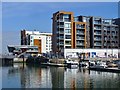
2
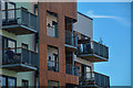
Portishead : Ninety4 on the Estuary
Consisting of 94 one and two-bedroom apartments, the development consists of three concrete-framed blocks that are raked in ascending order of height from four to six storeys.
Image: © Lewis Clarke
Taken: 2 Jun 2020
0.05 miles
3
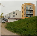
Far end of Pennant Place, Portishead
The view from the seaward side. Pennant Place houses were built c2008 and house construction in the area is continuing (as at April 2010).
Image: © Jaggery
Taken: 25 Apr 2010
0.06 miles
4
Scaffolded apartment block, Port Marine, Portishead
Image: © Jonathan Thacker
Taken: 6 Oct 2022
0.07 miles
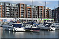
5
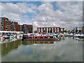
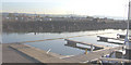
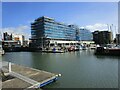
Portishead Marina
Portishead Marina showing moorings and the retail area off Newfoundland Way.
Photograph taken from the path beside Lockside on the western side of the marina.
Image: © Kevin Pearson
Taken: 9 Jun 2021
0.07 miles
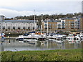
7
Portishead Marina
Redeveloped area replacing former docks and power station with housing, marina and shops.
Image: © Colin Smith
Taken: 25 Mar 2016
0.07 miles
9
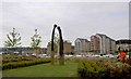
Marina sculpture Portishead
Looking like burnt matches one of many works street art around the marina area.
Image: © Steve Fareham
Taken: 8 Aug 2010
0.07 miles
10
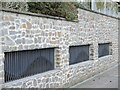
Wavy lines in the car park
Underneath the apartment blocks facing out to the channel are car parks. The ventilation grilles have a sea theme to them.
Image: © Neil Owen
Taken: 25 Feb 2022
0.07 miles