IMAGES TAKEN NEAR TO
Cedar Way, BRISTOL, BS20 6TT
Introduction
This page details the photographs taken nearby to Cedar Way, BS20 6TT by members of the Geograph project.
The Geograph project started in 2005 with the aim of publishing, organising and preserving representative images for every square kilometre of Great Britain, Ireland and the Isle of Man.

There are currently over 7.5m images from over14,400 individuals and you can help contribute to the project by visiting https://www.geograph.org.uk
Image Map (Loading...)


Getting Data...Please wait
Leaflet Map data © OpenStreetMap
Images are licensed for reuse under creativecommons.org/licenses/by-sa/2.0
Notes
- Clicking on the map will re-center to the selected point.
- The higher the marker number, the further away the image location is from the centre of the postcode.
Image Listing (15 Images Found)
Images are licensed for reuse under creativecommons.org/licenses/by-sa/2.0
Image
Details
Distance
1
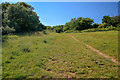
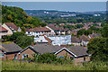
Portishead : Grassy Field
The right of way heads up the hillside.
Image: © Lewis Clarke
Taken: 2 Jun 2020
0.14 miles
2
Portishead : Grassy Field
Looking across a grassy field.
Image: © Lewis Clarke
Taken: 2 Jun 2020
0.16 miles
3
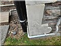
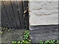
Ordnance Survey Cut Mark
This OS cut mark can be found on No58 Lower Down Road. It marks a point 77.242m above mean sea level.
Image: © Adrian Dust
Taken: 20 Aug 2022
0.16 miles
4

Ordnance Survey Cut Mark
This OS cut mark can be found on the retaining wall at the top of Newlands Road.
Image: © Adrian Dust
Taken: 20 Aug 2022
0.16 miles
5

Portishead : Footpath
A footpath heads across the hill.
Image: © Lewis Clarke
Taken: 2 Jun 2020
0.17 miles
6
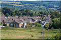
Portishead : Grassy Field
Looking across a grassy field above Portishead.
Image: © Lewis Clarke
Taken: 2 Jun 2020
0.18 miles
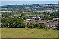
7
Portishead : Portishead Scenery
Looking across the town of Portishead.
Image: © Lewis Clarke
Taken: 2 Jun 2020
0.18 miles
8
Ordnance Survey Cut Mark
This OS cut mark can be found on the roadside building at Capenore Court. It marks a point 27.597m above mean sea level.
Image: © Adrian Dust
Taken: 14 Mar 2022
0.18 miles
9
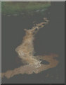
Flood sediment
This is the Flood of the Great Storm on the base of the Spring in Old Red Sandstone, fractured, but I am not sure when; I suspect 1995 summer or late, into autumn. It was not cold weather, just wet and people's gardens awash, or rather small rivers.
Image: © MDS
Taken: Unknown
0.19 miles
10
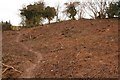
The Hedgerow Soil wash Mass Exposed
North Weston Wood Portishead Down (heavily poached winter soils on Down) quagmire and basin soaked soils in the valley to North Weston : the source of the Extreme Rabbit-ing is unknown, the entire hillside loose soil mass has been cleared of vegetation 2010
Image: © Michael Dennis Stagg
Taken: 25 Feb 2010
0.22 miles