IMAGES TAKEN NEAR TO
High Street, BRISTOL, BS20 6PW
Introduction
This page details the photographs taken nearby to High Street, BS20 6PW by members of the Geograph project.
The Geograph project started in 2005 with the aim of publishing, organising and preserving representative images for every square kilometre of Great Britain, Ireland and the Isle of Man.

There are currently over 7.5m images from over14,400 individuals and you can help contribute to the project by visiting https://www.geograph.org.uk
Image Map
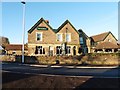
Images are licensed for reuse under creativecommons.org/licenses/by-sa/2.0
Notes
- Clicking on the map will re-center to the selected point.
- The higher the marker number, the further away the image location is from the centre of the postcode.
Image Listing (83 Images Found)
Images are licensed for reuse under creativecommons.org/licenses/by-sa/2.0
Image
Details
Distance
1
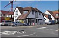
The Corner Cafe, 166 High Street, Portishead, Somerset
The café is located on the corner of the High Street and St. Peter's Road. The crane towering overhead is indicative of the large amount of residential building going on nearby.
Image: © P L Chadwick
Taken: 9 Jun 2013
0.03 miles
2
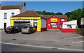
Portishead Tyre & MOT Centre, 160 High Street, Portishead, Somerset
Apparently this is the town's only independent "fast-fit centre". It is a MOT test centre, and includes Viper Valets. The centre was previously a Knights Tyre & Exhaust Centre.
Image: © P L Chadwick
Taken: 9 Jun 2013
0.03 miles
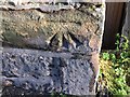
3
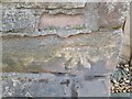
Ordnance Survey Cut Mark
This OS cut mark can be found on No147 High Street. It marks a point 7.550m above mean sea level.
Image: © Adrian Dust
Taken: 14 Mar 2022
0.04 miles
4
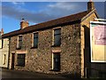
Portishead, 147 High Street
There is a cut bench mark on the south-west angle of the house. See http://www.geograph.org.uk/photo/5996882 for a closer view and https://www.bench-marks.org.uk/bm41404 for details of the mark.
Image: © Brian Westlake
Taken: 3 Dec 2018
0.04 miles
5
Cut Mark: Portishead, #147 High Street
Cut bench mark on the south-west angle of the house. See http://www.geograph.org.uk/photo/5996886 for a wider view and https://www.bench-marks.org.uk/bm41404 for details of the mark.
Image: © Brian Westlake
Taken: 3 Dec 2018
0.04 miles
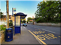
6
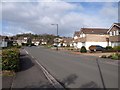
Brampton Way, Portishead
This is the principal road through a large housing estate on the south side of the town. In the background is Fore Hill.
Image: © Derek Harper
Taken: 1 Apr 2010
0.08 miles
7
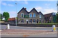
The Albion, 15 Bristol Road, Portishead, Somerset
A large pub near the edge of the town with an established food trade. It is a Greene King house. They are based at Bury St. Edmunds in Suffolk, where they have a brewery. Their pubs division has around 1,600 pubs at present, and has extended well beyond their East Anglian base, particularly as they have taken over many pubs from other now defunct breweries.
Image: © P L Chadwick
Taken: 9 Jun 2013
0.10 miles
9
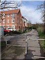
Footpath in Portishead
The public footpath links Forester Road with the High Street. The block of flats on the left is St Peter's Lodge.
Image: © Derek Harper
Taken: 1 Apr 2010
0.11 miles