IMAGES TAKEN NEAR TO
High Street, BRISTOL, BS20 6EW
Introduction
This page details the photographs taken nearby to High Street, BS20 6EW by members of the Geograph project.
The Geograph project started in 2005 with the aim of publishing, organising and preserving representative images for every square kilometre of Great Britain, Ireland and the Isle of Man.

There are currently over 7.5m images from over14,400 individuals and you can help contribute to the project by visiting https://www.geograph.org.uk
Image Map (Loading...)


Getting Data...Please wait
Leaflet Map data © OpenStreetMap
Images are licensed for reuse under creativecommons.org/licenses/by-sa/2.0
Notes
- Clicking on the map will re-center to the selected point.
- The higher the marker number, the further away the image location is from the centre of the postcode.
Image Listing (126 Images Found)
Images are licensed for reuse under creativecommons.org/licenses/by-sa/2.0
Image
Details
Distance
1
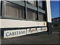
At the bottom of Cabstand
Signs at the junction with the A369. In the nineteenth century this spot was at the water's edge before the dock was built.
Image: © Neil Owen
Taken: 25 Feb 2022
0.01 miles
2
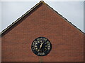
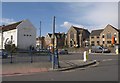
The time and the place
A clock on what is otherwise an unremarkable modern housing development off Cabstand.
Image: © Neil Owen
Taken: 25 Feb 2022
0.02 miles
3
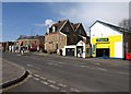
Station Road, Portishead
Burlington House, the gabled building on the corner of Station Road and Cabstand, houses a firm of funeral directors. The Rapid Fit garage actually encloses it, fronting onto Cabstand around the corner. The traffic lights aren't working, but this seems to have improved the flow of traffic.
Image: © Derek Harper
Taken: 1 Apr 2010
0.02 miles
4
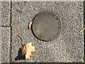
A disc to 'Timelines'
A trail of metal discs lead up to the tall sculpture 'Timelines'; most have a pattern inscribed on them. The discs increase in size as they approach it. See Image] for the artwork in town.
Image: © Neil Owen
Taken: 26 Oct 2022
0.02 miles
5
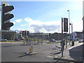
Lights Road
The Many Lights to the Roads.
Not quite a Bruce Springsteen lyric, but getting there.
This is the famed traffic light argument.
Image: © MDS
Taken: 26 Feb 2007
0.02 miles
6
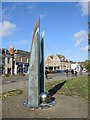
'Timelines'
An artwork by Marianne Forrest, Timelines is a pair of structures, made using textured and patinated bronze panels mounted on a framework of steel. At night the lights set into the glass base illuminate the pieces. A stainless steel ball completes the largest piece, with other smaller metal inlays set into the pavement nearby - see Image See also Image
Image: © Neil Owen
Taken: 26 Oct 2022
0.03 miles
7
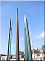
Looking up 'Timelines'
The sculpture close to the main roundabout in town has separate slices of metal and glass, which are illuminated at night. See Image
Image: © Neil Owen
Taken: 26 Oct 2022
0.03 miles
8
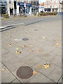
Circles leading to 'Timelines'
Leading from the tall sculpture (see Image]) are a set of cast metal discs, set into the pavement and of decreasing size. See Image] for a closer look at one.
Image: © Neil Owen
Taken: 26 Oct 2022
0.03 miles
9
Road junction, Portishead
Wyndham Way, the A369 (on the left) meets the High Street (the B3124) at these out-of-action traffic lights. On the left is the White Lion; across the road is Portishead Methodist Church and hall.
Image: © Derek Harper
Taken: 1 Apr 2010
0.04 miles
10

Standing mill stone
This mill stone used to work in the old Portishead Mill, some distance away, until it closed in the early 1800s. The stone has since been repositioned here against the restaurant, which itself lies on part of the old sea walls.
Image: © Neil Owen
Taken: 6 Jul 2023
0.04 miles