IMAGES TAKEN NEAR TO
Perrett Way, Ham Green, BRISTOL, BS20 0HX
Introduction
This page details the photographs taken nearby to Perrett Way, Ham Green, BS20 0HX by members of the Geograph project.
The Geograph project started in 2005 with the aim of publishing, organising and preserving representative images for every square kilometre of Great Britain, Ireland and the Isle of Man.

There are currently over 7.5m images from over14,400 individuals and you can help contribute to the project by visiting https://www.geograph.org.uk
Image Map (Loading...)


Getting Data...Please wait
Leaflet Map data © OpenStreetMap
Images are licensed for reuse under creativecommons.org/licenses/by-sa/2.0
Notes
- Clicking on the map will re-center to the selected point.
- The higher the marker number, the further away the image location is from the centre of the postcode.
Image Listing (58 Images Found)
Images are licensed for reuse under creativecommons.org/licenses/by-sa/2.0
Image
Details
Distance
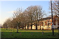
1
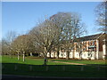
An avenue in Ham Green
The new row of houses stand roughly on the site of part of the old Ham Green hospital.
Image: © Neil Owen
Taken: 19 Nov 2020
0.01 miles
3
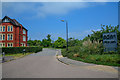
Pill : Macrae Road
The road heads to Eden Office Park.
Image: © Lewis Clarke
Taken: 26 Jun 2020
0.03 miles
4
Pill : Macrae Road
Looking along Macrae Road and the open space.
Image: © Lewis Clarke
Taken: 26 Jun 2020
0.03 miles
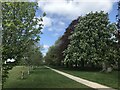
5
Houses at Ham Green
These houses are just off Macrae Street next to a park which sits on top of the Pill tunnel of the Portishead branch railway line. This is looking west along the line of the tunnel which runs parallel to the line of trees on the left of the image.
Image: © Nigel Mykura
Taken: 20 Jan 2017
0.03 miles
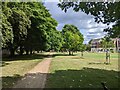
8
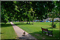
Pill : Ham Green
Looking across the public space.
Image: © Lewis Clarke
Taken: 26 Jun 2020
0.03 miles
9
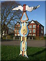
Back of the cycle signpost
A National Cycle Network marker in Ham Green, still directing between Bristol and Pill on its rear aspect.
Image: © Neil Owen
Taken: 19 Nov 2020
0.04 miles
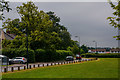
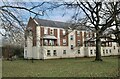
10
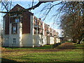
Backing onto Perrett Way
A row of town houses face an avenue. The houses stand on what was a wing of the former Infectious Diseases hospital of old.
Image: © Neil Owen
Taken: 19 Nov 2020
0.04 miles