IMAGES TAKEN NEAR TO
Monmouth Road, BRISTOL, BS20 0AY
Introduction
This page details the photographs taken nearby to Monmouth Road, BS20 0AY by members of the Geograph project.
The Geograph project started in 2005 with the aim of publishing, organising and preserving representative images for every square kilometre of Great Britain, Ireland and the Isle of Man.

There are currently over 7.5m images from over14,400 individuals and you can help contribute to the project by visiting https://www.geograph.org.uk
Image Map
Images are licensed for reuse under creativecommons.org/licenses/by-sa/2.0
Notes
- Clicking on the map will re-center to the selected point.
- The higher the marker number, the further away the image location is from the centre of the postcode.
Image Listing (118 Images Found)
Images are licensed for reuse under creativecommons.org/licenses/by-sa/2.0
Image
Details
Distance
1
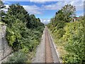
Pill railway station (site), Somerset
Opened in 1867 by the Bristol & Portishead Railway between those two places, later part of the Great Western Railway, this station closed in 1964.
View north west towards Portbury and Portishead, with the Bristol-bound platform visible to the right of the track. The left handed platform was still extant but covered in vegetation.
Image: © Nigel Thompson
Taken: 25 Sep 2021
0.02 miles
2
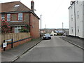
Crusty Lane
It's tempting to expect that there used to be a bakery around here in the past, but it seems not. The road leads into Monmouth Road, itself a recent addition to Pill in around the early twentieth century. The lane is close to a former pub, though, which has been replaced with modern housing.
Image: © Neil Owen
Taken: 22 Mar 2023
0.03 miles

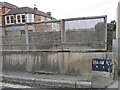
4

At Pill Station Overbridge
Looking northwards
Image: © Anthony O'Neil
Taken: 21 Jan 2022
0.05 miles

6

Beating the energy hike
Sambourne Lane, Pill
Image: © Anthony O'Neil
Taken: 21 Jan 2022
0.06 miles
7

Back Lane steps
To Pump Square, Pill
Image: © Anthony O'Neil
Taken: 21 Jan 2022
0.06 miles
8
Handpainted railway sign
The line from Pill is some 126 miles, 8 3⁄4 chains to London, presumably.
Image: © Neil Owen
Taken: 22 Mar 2023
0.07 miles
9
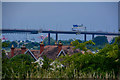
Pill : Rooftops
Rooftops at Pill with the M5 Motorway bridge in the distance.
Image: © Lewis Clarke
Taken: 26 Jun 2020
0.07 miles
10

Pill Station Overbridge
Myrtle Hill, looking southwards
Image: © Anthony O'Neil
Taken: 21 Jan 2022
0.07 miles