IMAGES TAKEN NEAR TO
BS18 2RZ
Introduction
This page details the photographs taken nearby to BS18 2RZ by members of the Geograph project.
The Geograph project started in 2005 with the aim of publishing, organising and preserving representative images for every square kilometre of Great Britain, Ireland and the Isle of Man.

There are currently over 7.5m images from over14,400 individuals and you can help contribute to the project by visiting https://www.geograph.org.uk
Image Map
Images are licensed for reuse under creativecommons.org/licenses/by-sa/2.0
Notes
- Clicking on the map will re-center to the selected point.
- The higher the marker number, the further away the image location is from the centre of the postcode.
Image Listing (4 Images Found)
Images are licensed for reuse under creativecommons.org/licenses/by-sa/2.0
Image
Details
Distance
1
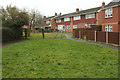
Walton Close, Keynsham
A path leads through from the cul-de-sac to Rowan Walk and Longmeadow Road.
Image: © Derek Harper
Taken: 10 Mar 2018
0.09 miles
2
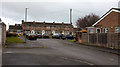
Birch Court, Keynsham
A cul-de-sac off Longmeadow Road, with a terrace of six facing the camera.
Image: © Derek Harper
Taken: 10 Mar 2018
0.10 miles
3
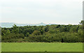
2010 : Due east from Charlton Road near Keynsham
Abbots Wood lies beyond the pasture, marked on OS Explorer Map 155 as "Access land."
Kelston Round Hill stands faint on the horizon Image Lansdown is to the left.
Image: © Maurice Pullin
Taken: 6 Sep 2010
0.21 miles
4
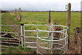
Footpath to Queen Charlton
A kissing gate at the start of footpath BA 27/13#1 where it leaves Charlton Road.
Image: © Derek Harper
Taken: 10 Mar 2018
0.22 miles