IMAGES TAKEN NEAR TO
BS17 6QH
Introduction
This page details the photographs taken nearby to BS17 6QH by members of the Geograph project.
The Geograph project started in 2005 with the aim of publishing, organising and preserving representative images for every square kilometre of Great Britain, Ireland and the Isle of Man.

There are currently over 7.5m images from over14,400 individuals and you can help contribute to the project by visiting https://www.geograph.org.uk
Image Map
Images are licensed for reuse under creativecommons.org/licenses/by-sa/2.0
Notes
- Clicking on the map will re-center to the selected point.
- The higher the marker number, the further away the image location is from the centre of the postcode.
Image Listing (7 Images Found)
Images are licensed for reuse under creativecommons.org/licenses/by-sa/2.0
Image
Details
Distance
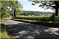
2
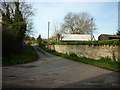
Horton Road near Horton
Looking east along Horton Road on the edge of Horton village.
Image: © Ruth Riddle
Taken: 25 Feb 2012
0.08 miles
3
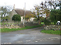
Horseshoe Farm
Thatched farmhouse at Horton near Chipping Sodbury
Image: © Anne Pollitt
Taken: 11 Nov 2006
0.11 miles
4
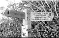
Cotswold Way Sign, Horton, Gloucestershire 2013
Image: © Ray Bird
Taken: 30 Oct 2013
0.12 miles
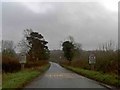
5
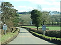
Horton Road
Horton Road approaching the village of Horton from the south-west. Viewed from it junction with Mapleridge Lane.
Image: © Philip Halling
Taken: 26 Sep 2015
0.16 miles
7
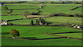
Field boundaries W of Horton Farm as seen from N of Horton Hill Fort
Image: © Colin Park
Taken: 5 Nov 2017
0.24 miles