IMAGES TAKEN NEAR TO
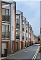
Barossa Place, BRISTOL, BS1 6SU
Introduction
This page details the photographs taken nearby to Barossa Place, BS1 6SU by members of the Geograph project.
The Geograph project started in 2005 with the aim of publishing, organising and preserving representative images for every square kilometre of Great Britain, Ireland and the Isle of Man.

There are currently over 7.5m images from over14,400 individuals and you can help contribute to the project by visiting https://www.geograph.org.uk
Image Map
Images are licensed for reuse under creativecommons.org/licenses/by-sa/2.0
Notes
- Clicking on the map will re-center to the selected point.
- The higher the marker number, the further away the image location is from the centre of the postcode.
Image Listing (1603 Images Found)
Images are licensed for reuse under creativecommons.org/licenses/by-sa/2.0
Image
Details
Distance
2
Santa comes to Bristol
Guinea Street
Image: © Anthony O'Neil
Taken: 20 Dec 2020
0.01 miles
3
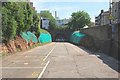
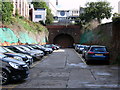
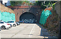
Redcliffe Tunnel
(1872 ~ 1964) This is the western end of the disused railway tunnel through Redcliffe Hill, close to St Mary Redcliffe church. It used to take goods transported between Bristol Harbour and Temple Meads station. The Docks railway crossed Bathurst Basin via a swing bridge which now carries pedestrians and cyclists.
Image: © Anthony O'Neil
Taken: 9 May 2020
0.01 miles
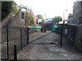
4
Disused tracks at Bathurst Basin
With what looks like a blocked up railway tunnel in the background.
Image: © Thomas Nugent
Taken: 28 Sep 2010
0.01 miles
5
Car park near Bathurst Basin
With what looks like a blocked up railway tunnel in the background.
Image: © Thomas Nugent
Taken: 28 Sep 2010
0.01 miles
6
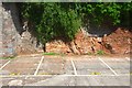
Sedimentary strata
Evidence of the geological basis of the naming of this area of Bristol - 'Redcliffe'.
Ironically, having originated through the steady accumulation of sand grains, on the ocean floor, the resulting rock has been mined and crushed to return it to sand for building. The historic 'caves' created by this industrial process are still partially accessible, nearby, at Redcliffe Quay.
Image: © Anthony O'Neil
Taken: 9 May 2020
0.01 miles
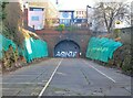
7
Towards the western portal of a former Redcliffe railway tunnel, Bristol
Viewed from the east side of the Bathurst Basin looking along a former
railway route, towards a 250 metres long tunnel under Redcliffe Hill.
Image: © Jaggery
Taken: 21 Oct 2012
0.02 miles
8
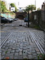
Quondam railway
Adjacent to Guinea Street: the Docks railway branch line from nearby Temple Meads Station used to emerge here and run across the small swing bridge (extant) over
Bathurst Basin and along the Floating Harbour. Only the sunken lines remain (in places), the freight trains having ceased long ago. Although sealed at both ends, the tunnel still exists beneath St Mary Redcliffe churchyard, and has been used in the past for storage.
(Now that some of Dr Beeching's mainline rail closures are being reversed, who knows whether the tunnel might re-open at some time.)
Image: © Anthony O'Neil
Taken: 10 Jan 2021
0.02 miles
9
Former railway tunnel, Bristol
This blocked entrance was for the branch from the Bristol Harbour Railway to Temple Meads Station and is by Bathurst Basin.
Image: © Chris Allen
Taken: 16 Jul 2022
0.02 miles
10
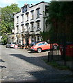
The Ostrich Inn
Overlooking Bathurst Basin.
Image: © Thomas Nugent
Taken: 28 Sep 2010
0.02 miles