IMAGES TAKEN NEAR TO
Castle Road, BRISTOL, BS16 9UF
Introduction
This page details the photographs taken nearby to Castle Road, BS16 9UF by members of the Geograph project.
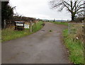
The Geograph project started in 2005 with the aim of publishing, organising and preserving representative images for every square kilometre of Great Britain, Ireland and the Isle of Man.

There are currently over 7.5m images from over14,400 individuals and you can help contribute to the project by visiting https://www.geograph.org.uk
Image Map
Images are licensed for reuse under creativecommons.org/licenses/by-sa/2.0
Notes
- Clicking on the map will re-center to the selected point.
- The higher the marker number, the further away the image location is from the centre of the postcode.
Image Listing (149 Images Found)
Images are licensed for reuse under creativecommons.org/licenses/by-sa/2.0
Image
Details
Distance
1
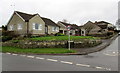
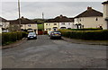
Castle Road bungalows, Pucklechurch
At the southeast end of Castle Road, viewed across Feltham Road.
Image: © Jaggery
Taken: 5 Feb 2016
0.01 miles
2
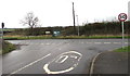
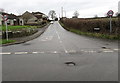
Junction of Castle Road and Feltham Road, Pucklechurch
The 20mph speed limit on Castle Road increases to 30 on Feltham Road.
The green cabinet is part of Pucklechurch CSO http://www.geograph.org.uk/photo/4817119 at the edge of Feltham Road.
Image: © Jaggery
Taken: 5 Feb 2016
0.03 miles
3
Feltham Road, Pucklechurch
Viewed from the corner of Castle Road. Pucklechurch CSO http://www.geograph.org.uk/photo/4817119 is on the right.
Image: © Jaggery
Taken: 5 Feb 2016
0.03 miles
4
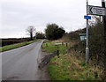
Directions at the edge of Pucklechurch
Ahead along Feltham Road on National Cycle Network Route 17 or
turn left into Castle Road http://www.geograph.org.uk/photo/4817069 for Pucklechurch Primary School.
Image: © Jaggery
Taken: 5 Feb 2016
0.03 miles
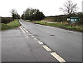
5
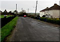
Castle Road, Pucklechurch
The 30mph speed limit on Feltham Road drops to 20mph on Castle Road on the approach to the village primary school.
Image: © Jaggery
Taken: 5 Feb 2016
0.03 miles
6
Hill View Road houses, Pucklechurch
Viewed from the main part of Hill View Road (aligned NE-SW). This spur of Hill View Road is aligned NW-SE.
Image: © Jaggery
Taken: 5 Feb 2016
0.03 miles
7
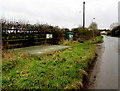
Pucklechurch CSO (Combined Sewer Overflow)
The Wessex Water site is alongside Feltham Road near the Castle Road junction.
The identifier on the green cabinet is 16559 PUCKLECHURCH CSO FELTHAM ROAD.
Image: © Jaggery
Taken: 5 Feb 2016
0.04 miles
8
Hill View Road towards Castle Road, Pucklechurch
A children's playground http://www.geograph.org.uk/photo/4836929 is ahead on the left.
Image: © Jaggery
Taken: 5 Feb 2016
0.04 miles
9
Entrance to Marsh Farm, Pucklechurch
From Feltham Road. A notice on the left states MARSH FARM supplier of top quality Farm Assured Milk.
Image: © Jaggery
Taken: 5 Feb 2016
0.05 miles
10
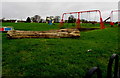
Children's playground, Pucklechurch
On the corner of Castle Road and Hill View Road.
Image: © Jaggery
Taken: 5 Feb 2016
0.05 miles