IMAGES TAKEN NEAR TO
Merlin Ridge, BRISTOL, BS16 9SU
Introduction
This page details the photographs taken nearby to Merlin Ridge, BS16 9SU by members of the Geograph project.
The Geograph project started in 2005 with the aim of publishing, organising and preserving representative images for every square kilometre of Great Britain, Ireland and the Isle of Man.

There are currently over 7.5m images from over14,400 individuals and you can help contribute to the project by visiting https://www.geograph.org.uk
Image Map (Loading...)


Getting Data...Please wait
Leaflet Map data © OpenStreetMap
Images are licensed for reuse under creativecommons.org/licenses/by-sa/2.0
Notes
- Clicking on the map will re-center to the selected point.
- The higher the marker number, the further away the image location is from the centre of the postcode.
Image Listing (36 Images Found)
Images are licensed for reuse under creativecommons.org/licenses/by-sa/2.0
Image
Details
Distance
1
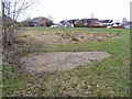
Barrage balloon mooring site
The semi-circle of more scrubby looking grass is the location of a World War Two barrage balloon mooring site in Pucklechurch. There are various small concrete pads set into this area of ground, some with metal rings attached, and also the outline of a small building. The exposed concrete in the foreground is the most obvious feature that would be evident to a casual observer visiting this site.
Image: © Ruth Riddle
Taken: 29 Jan 2011
0.11 miles
2
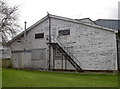
Number 11 Balloon Centre hangar
The end of one of the remaining barrage balloon sheds at Pucklechurch, now an empty industrial unit, retains some of its original features. There are two hangars that are extant, but there were also two other, shorter, blocks that held repair and training facilities - both are now gone.
See Image] for more.
Image: © Neil Owen
Taken: 16 Feb 2017
0.13 miles
3
More open to the elements
The side of one of the old barrage balloon units at the former Pucklechurch station shows some fire damage. See Image] for more.
Image: © Neil Owen
Taken: 16 Feb 2017
0.14 miles
4
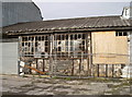
Burnt out
The old barrage balloon hangar was built with lots of asbestos sheeting - unsurprisingly when you consider that a balloon held over 500m³ (17,000cf) of flammable hydrogen! However, the balloons and the asbestos are long gone - a pity as this fire broke out. See Image] for more.
Image: © Neil Owen
Taken: 16 Feb 2017
0.14 miles
5
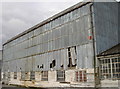
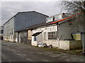
Balloon Centre Number 11
Pucklechurch was a prime site in the preparations for the outbreak of WWII. After tentative trials the need for a defensive system using balloons to protect vital installations was revived and improved at Cardington in Befordshire. By 1939, a national network was formed to base the balloons around; Pucklechurch was Number 11.
This hangar was built with mansard-like roofs and large windows high in the walls on three sides. The lower workshops are clad in horizontal timber boards and have multi-pane steel-frame windows and dormers.
However, these days the old sheds are part of the Pucklechurch Trading Estate, and have had various occupants. A fire in the adjoining unit has brought it to an uncertain point in its history. Grade II listed.
See Image] for more.
Image: © Neil Owen
Taken: 16 Feb 2017
0.16 miles
6
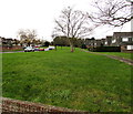
Grass, trees and houses, Pucklechurch
Oaktree Avenue is on the left.
Image: © Jaggery
Taken: 5 Feb 2016
0.16 miles
7
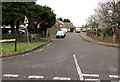
St Aldams Drive, Pucklechurch
Looking ESE along St Aldams Drive from Becket Court.
Image: © Jaggery
Taken: 5 Feb 2016
0.18 miles
8
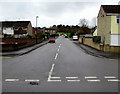
Oaktree Avenue, Pucklechurch
Viewed across Abson Road.
Image: © Jaggery
Taken: 5 Feb 2016
0.18 miles
9
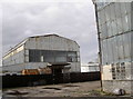
Full of light and air - and hydrogen!
Both the former barrage balloon hangars in Pucklechurch have survived the war and a number of recessions, although they are now unoccupied and fenced off following a fire.
Pucklechurch was the home of Number 11 Centre, opening in 1939 and providing defensive capabilities for the Bristol area. It also held training and repair facilities for most of the war. As it drew to a close and the need for balloons diminished, the site was converted to various maintenance and storage uses as R.A.F. Pucklechurch. This carried on into the 1950s and finally shut to the military in 1962. It is now an industrial estate.
See Image] for more.
Image: © Neil Owen
Taken: 16 Feb 2017
0.18 miles
10
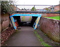
Southeast side of a pedestrian underpass, Pucklechurch
Under Oaktree Avenue.
Image: © Jaggery
Taken: 5 Feb 2016
0.19 miles