IMAGES TAKEN NEAR TO
Coxgrove Hill, BRISTOL, BS16 9NL
Introduction
This page details the photographs taken nearby to Coxgrove Hill, BS16 9NL by members of the Geograph project.
The Geograph project started in 2005 with the aim of publishing, organising and preserving representative images for every square kilometre of Great Britain, Ireland and the Isle of Man.

There are currently over 7.5m images from over14,400 individuals and you can help contribute to the project by visiting https://www.geograph.org.uk
Image Map (Loading...)


Getting Data...Please wait
Leaflet Map data © OpenStreetMap
Images are licensed for reuse under creativecommons.org/licenses/by-sa/2.0
Notes
- Clicking on the map will re-center to the selected point.
- The higher the marker number, the further away the image location is from the centre of the postcode.
Image Listing (20 Images Found)
Images are licensed for reuse under creativecommons.org/licenses/by-sa/2.0
Image
Details
Distance
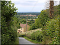
1

2011 : Coxgrove Hill
Looking up the hill toward Parkfield and Pucklechurch.
Image: © Maurice Pullin
Taken: 20 Jun 2011
0.04 miles
2
2011 : On Coxgrove Hill, near the top
Looking north west down the hill over South Gloucestershire.
An area riddled with disused coal mines, though it would take a sharp eye to find one here.
The M4 is (thankfully) only just to be seen about half way up the frame followed by Winterbourne. The hills faintly seen in the blue yonder are on the other side of the Bristol Channel.
Image: © Maurice Pullin
Taken: 20 Jun 2011
0.07 miles
3
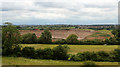
2011 : West of north on Coxgrove Hill
Looking toward Winterbourne in the distance centre frame with Frampton Cottrell and Coalpit Heath to the right. Another reminder of the South Gloucester coalfield is the mine chimney almost hidden in the trees further down.
A landfill site comes between with a red delivery lorry and at least two earth movers. An ugly scar at the moment but when finished will be a great improvement on the quarry that was there before.
Image: © Maurice Pullin
Taken: 20 Jun 2011
0.10 miles
4
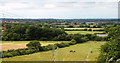
2011 : View west from Coxgrove Hill
A power line intrudes as we look a little north of west across long disused pits in the South Gloucestershire coalfield. An old chimney stands at the edge of the frame, pylons show that time moves on. The horses and cows are happily munching their grass.
A good deal of interest in the larger version of this image, bits of east and north Bristol, hills on the other side of the Severn Estuary are faint in the distance.
Image: © Maurice Pullin
Taken: 20 Jun 2011
0.11 miles
5

2011 : Minor road to Coxgrove Hill
Just round the next bend for a view over South Gloucestershire.
Image: © Maurice Pullin
Taken: 20 Jun 2011
0.21 miles
6
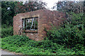
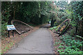
Former railway building near Pucklechurch
On the cycleway and footpath that uses an old railway line and passes Brandy Bottom Colliery. This derelict building was associated with the railway.
Image: © Chris Allen
Taken: 10 Sep 2022
0.23 miles
7
Former pit wheel by Brandy Bottom Colliery
On the former Dramway that is now a public footpath and goes past this former colliery site that is a Scheduled Ancient Monument.
Image: © Chris Allen
Taken: 10 Sep 2022
0.24 miles
8

Winding Wheel from Brandy Bottom Colliery
There were at least 10 coal mines within a mile from this spot. This is the winding wheel from Brandy Bottom Colliery, lying next to the cycle path.
Image: © Linda Bailey
Taken: 12 Sep 2006
0.24 miles
9
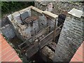
Brandy Bottom Colliery - beam winding engine house
This Scheduled Ancient Monument is on the South Gloucestershire Coalfield in the parish of Pucklechurch. The first pits on site date back to around 1837 although the name Brandy Bottom is first noted in 1856. A new pit was sunk in 1871 and is separated from the complex of buildings represented by this engine house. Coal drawing at Brandy Bottom ceased before WWI and the pit was then used to ventilate another nearby mine. All operations ceased in 1936.
This engine house belongs to the old pit and could therefore date to about 1837. It is described on the website as the 'vertical engine house' but quite clearly contained a rotative beam engine. On the left is the cylinder loading and in front of it the pit for the condenser. Just to the left of the wooden bridge is the cross wall that would have carried the supports for the entablature. The narrow slot to the right is interpreted as holding the flywheel.
An auction catalogue of 1900 describes what may well have been the engine in this house: - Old Pit winding engine - Condensing winding engine, 24 inch cylinders, 4 foot 6 inch stroke, 2 gearing wheels, fly wheels, barrel drum 13 feet diameter, 380 yards 1 1/8 inch steel wire rope, wrought iron cage 6 cwts. Head gear 13 feet pulley wheel. Pit bank 40 feet by 40 feet.
Image: © Chris Hodrien
Taken: 3 Sep 2017
0.24 miles
10
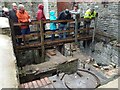
Brandy Bottom Colliery - beam winding engine house
This Scheduled Ancient Monument is on the South Gloucestershire Coalfield in the parish of Pucklechurch. The first pits on site date back to around 1837 although the name Brandy Bottom is first noted in 1856. A new pit was sunk in 1871 and is separated from the complex of buildings represented by this engine house. Coal drawing at Brandy Bottom ceased before WWI and the pit was then used to ventilate another nearby mine. All operations ceased in 1936.
This engine house belongs to the old pit and could therefore date to about 1837. It is described on the website as the 'vertical engine house' but quite clearly contained a rotative beam engine. In the foreground is the cylinder loading and just beyond it is the pit for the condenser. Just in front of the wooden bridge is the cross wall that would have carried the supports for the entablature. The narrow slot to the right is interpreted as holding the flywheel. The larger space under the right hand end of the bridge was probably where the winding drum was. The big wall on the right is the pit bank. Seen during a visit with the South Gloucestershire Mines Research Group.
An auction catalogue of 1900 describes what may well have been the engine in this house: - Old Pit winding engine - Condensing winding engine, 24 inch cylinders, 4 foot 6 inch stroke, 2 gearing wheels, fly wheels, barrel drum 13 feet diameter, 380 yards 1 1/8 inch steel wire rope, wrought iron cage 6 cwts. Head gear 13 feet pulley wheel. Pit bank 40 feet by 40 feet.
Image: © Chris Hodrien
Taken: 3 Sep 2017
0.24 miles