IMAGES TAKEN NEAR TO
Richmond Road, BRISTOL, BS16 9EZ
Introduction
This page details the photographs taken nearby to Richmond Road, BS16 9EZ by members of the Geograph project.
The Geograph project started in 2005 with the aim of publishing, organising and preserving representative images for every square kilometre of Great Britain, Ireland and the Isle of Man.

There are currently over 7.5m images from over14,400 individuals and you can help contribute to the project by visiting https://www.geograph.org.uk
Image Map (Loading...)


Getting Data...Please wait
Leaflet Map data © OpenStreetMap
Images are licensed for reuse under creativecommons.org/licenses/by-sa/2.0
Notes
- Clicking on the map will re-center to the selected point.
- The higher the marker number, the further away the image location is from the centre of the postcode.
Image Listing (37 Images Found)
Images are licensed for reuse under creativecommons.org/licenses/by-sa/2.0
Image
Details
Distance
1
The Lamb Inn, Mangotsfield
This was originally comprised of 3 cottages, and date from 1596. There are references to a brewhouse in 1737. Most of the present structure dates from the 19th century.
Image: © Linda Bailey
Taken: 24 May 2006
0.09 miles
2
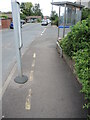
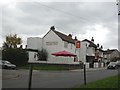
A narrow stop
Some odd lines by a bus stop, predating Covid.
Image: © Neil Owen
Taken: 24 Jun 2021
0.10 miles
3
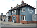
The Lamb Inn is open
Following the woes of the Covid-19 lockdown of early 2021, the pub industry is trying to regenerate the lost income this summer. There are plenty of offers and new methods of using smart technology to bring the customers back.
Image: © Neil Owen
Taken: 24 Jun 2021
0.10 miles
4
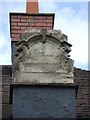
Little left to decipher
One of the chimney surrounds on the Lamb Inn has lost nearly all of its former glory. See Image] for the slightly better twin.
Image: © Neil Owen
Taken: 24 Jun 2021
0.10 miles
5
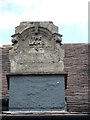
Inscribed inn
A detail of the Lamb Inn, Mangotsfield. Fortunately, it is still legible, although some of the finer features are lost now. See Image] for a twin in comparison.
Image: © Neil Owen
Taken: 24 Jun 2021
0.11 miles
6
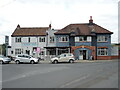
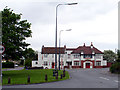
The Lamb Inn on Windsor Place
A pub built around the turn of the 1900s in front of the small common. The area used to have a colliery nearby, so possibly the trade would have relied on thirsty diggers in the past.
Image: © Neil Owen
Taken: 24 Jun 2021
0.11 miles
7
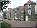
Where once there was learning
This modern development of apartments stands on what was the old Mangotsfield Church of England school. That was itself derived from earlier attempts to school local children in what, was at the time, a rural location. There were several attempts to organise education, with some church schools and Dame schools founded, including use of the former workhouse gardens. But the real thrust occurred with the opening of Mangotsfield Church of England School on January 10th, 1876. By 1899 a Mission Room was added; the school served as an air raid centre in WWII, and later found use by the Scouts.
However, the school was closed in 1999 and the pupils sent elsewhere. It was left to rack and ruin, later for a developer to build these houses in 2018. To mark the site of the old school, a sculpture was commissioned - see Image
Image: © Neil Owen
Taken: 24 Jun 2021
0.11 miles
8
Mangotsfield, Lamb Inn
Suburban pub on St James Street. Internally, L-shaped bar, with drinking and eating areas to left, front and right; games machines, TV, music. Cask ales on offer at my visit: Bass, St Austell Tribute.
Image: © Mike Faherty
Taken: 29 Oct 2010
0.11 miles
9
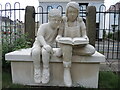
A nod to the learning
An unusual sort of statue: two children reading a book. This monument was created by a former local artist, Tom Whitehead, and cost £15,000; it marks an old entrance to the former Mangotsfield Church of England School that stood along this road from 1876 until 1999. The site remained derelict until deomlition in 2018, whereupon Cotswold Homes built a large housing block on it, and as part of the works paid for this memorial.
Image: © Neil Owen
Taken: 24 Jun 2021
0.11 miles
10
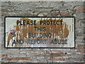
Please protect this building
An inevitable regard. This is inside the old building on the disused burial ground.
Image: © Neil Owen
Taken: 24 Jun 2021
0.13 miles