IMAGES TAKEN NEAR TO
Harebell Road, BS16 7PZ
Introduction
This page details the photographs taken nearby to Harebell Road, BS16 7PZ by members of the Geograph project.
The Geograph project started in 2005 with the aim of publishing, organising and preserving representative images for every square kilometre of Great Britain, Ireland and the Isle of Man.

There are currently over 7.5m images from over14,400 individuals and you can help contribute to the project by visiting https://www.geograph.org.uk
Image Map (Loading...)


Getting Data...Please wait
Leaflet Map data © OpenStreetMap
Images are licensed for reuse under creativecommons.org/licenses/by-sa/2.0
Notes
- Clicking on the map will re-center to the selected point.
- The higher the marker number, the further away the image location is from the centre of the postcode.
Image Listing (14 Images Found)
Images are licensed for reuse under creativecommons.org/licenses/by-sa/2.0
Image
Details
Distance
1
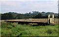
2011 : Making hay south of Howsmoor Lane
Near Hallen Farm.
The grass has been cut and is being raked into ridges for drying. A trailer waits to take it away when baled. (could be for silage)
Image: © Maurice Pullin
Taken: 2 Sep 2011
0.04 miles
2
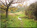
Path, Lyde Green
Footpath LPU/3 makes its soggy way past bushes and trees towards Whitehouse Farm.
Image: © Derek Harper
Taken: 22 Nov 2013
0.07 miles
3
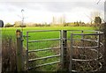
Kissing gate, Lyde Green
Giving access to footpath LPU/1 from footpath LPU/3. See (next) The field is access land, part of Lyde Green Common, which should survive development in this area.
Image: © Derek Harper
Taken: 22 Nov 2013
0.07 miles
4
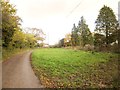
Lyde Green
The end of Howsmoor Lane, and the start of footpath LPU/3. This area, part of Lyde Green Common and access land, should survive as a green space as Emersons Green East is developed.
Image: © Derek Harper
Taken: 22 Nov 2013
0.11 miles
5
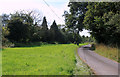
2011 : Howsmoor Lane looking west
Near Hallen Farm. Heading toward Vinny Green and a roundabout on the Avon Ring Road.
Image: © Maurice Pullin
Taken: 2 Sep 2011
0.13 miles
6
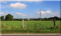
2011 : East at the end of Howsmoor Lane
Gate and pasture near Whitehouse Farm.
Traffic on the M4 can be seen beyond the electricity pylon.
The area is in the South Gloucestershire Coalfield, there are old shafts on the distant hill.
Image: © Maurice Pullin
Taken: 2 Sep 2011
0.14 miles
7
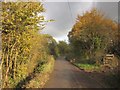
Howsmoor Lane
From the same spot as Image], looking towards Lyde Green.
Image: © Derek Harper
Taken: 22 Nov 2013
0.15 miles
8
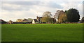
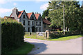
Whitehouse Farm
Seen across the meadow visible in Image] from the kissing gate. The farmhouse, originally C17, is listed http://list.english-heritage.org.uk/resultsingle.aspx?uid=1212367&searchtype=mapsearch . The field is access land, part of Lyde Green Common, which should survive development in this area.
Image: © Derek Harper
Taken: 22 Nov 2013
0.15 miles
9
2011 : Howsmoor Boarding Kennels and Cattery
At the end of Howsmoor Lane, unlikely to cause great disturbance for the neighbours.
Image: © Maurice Pullin
Taken: 2 Sep 2011
0.16 miles
10
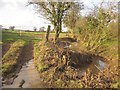
Tributary of the Folly Brook
The stream is the parish boundary between Mangotsfield Rural (left) and Pucklechurch. Here it is crossed by Howsmoor Lane.
Image: © Derek Harper
Taken: 22 Nov 2013
0.16 miles