IMAGES TAKEN NEAR TO
Newlands Lane, BRISTOL, BS16 7PT
Introduction
This page details the photographs taken nearby to Newlands Lane, BS16 7PT by members of the Geograph project.
The Geograph project started in 2005 with the aim of publishing, organising and preserving representative images for every square kilometre of Great Britain, Ireland and the Isle of Man.

There are currently over 7.5m images from over14,400 individuals and you can help contribute to the project by visiting https://www.geograph.org.uk
Image Map
Images are licensed for reuse under creativecommons.org/licenses/by-sa/2.0
Notes
- Clicking on the map will re-center to the selected point.
- The higher the marker number, the further away the image location is from the centre of the postcode.
Image Listing (22 Images Found)
Images are licensed for reuse under creativecommons.org/licenses/by-sa/2.0
Image
Details
Distance
1
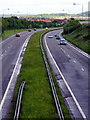
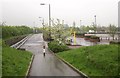
Ring Road A4174 looking north-west
On the pedestrian bridge/cycle route looking down onto the ring-road.
Image: © Linda Bailey
Taken: 24 May 2006
0.06 miles
2
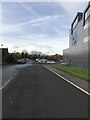
Access Road and National Composites Centre Car Park
Image: © Darren Haddock
Taken: 16 Oct 2017
0.07 miles
3
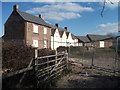
Newlands Farm saved
Newlands Farm farmhouse - derelict and abandoned for years following the building of the A4174 ring road metres from its front door - after having been re-roofed and preserved in the plan for Bristol Science Park.
Image: © Steve Coffin
Taken: 31 Mar 2013
0.08 miles
4
The 2nd Part of the Owl and Pussy Cat Poem
The 2nd half of the Owl and Pussy Cat Poem showing its position on a very small green in front of housing in Vinny Green. See Image for a closer view.
Image: © Linda Bailey
Taken: 24 May 2006
0.12 miles
5
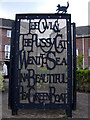
The Owl and the Pussy Cat
There were two of these 3-piece panels which told the story of the Owl and the Pussy Cat's vogage.
Image: © Linda Bailey
Taken: 24 May 2006
0.13 miles
6
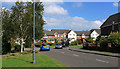
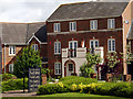
2011 : Emersons Way, New England, Mangotsfield
Near the southern end of Thomas Avenue.
A modern housing development, must say this is a great improvement on the stuff they were building in the 1950's and 60's, looks almost good enough to live in.
Image: © Maurice Pullin
Taken: 2 Sep 2011
0.14 miles
7
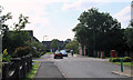
2011 : Emersons Way looking west
Adderley Gate is to the left with a post box opposite.
Image: © Maurice Pullin
Taken: 2 Sep 2011
0.18 miles
8
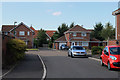
2011 : Thomas Avenue. New England, Mangotsfield
Or it may be Emerson's Green, or Vinny Green perhaps.
Image: © Maurice Pullin
Taken: 2 Sep 2011
0.19 miles
9
Supermarket car park, Emerson's Green
The northern corner of the Sainsbury's car park shown in Image The A4174 ring road run behind the hedge on the left.
Image: © Derek Harper
Taken: 22 Apr 2014
0.20 miles
10
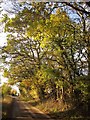
Howsmoor Lane
The stretch of lane that ran past the now demolished Hytoken House.
Image: © Derek Harper
Taken: 22 Nov 2013
0.20 miles