IMAGES TAKEN NEAR TO
Bromley Heath Road, BRISTOL, BS16 6JN
Introduction
This page details the photographs taken nearby to Bromley Heath Road, BS16 6JN by members of the Geograph project.
The Geograph project started in 2005 with the aim of publishing, organising and preserving representative images for every square kilometre of Great Britain, Ireland and the Isle of Man.

There are currently over 7.5m images from over14,400 individuals and you can help contribute to the project by visiting https://www.geograph.org.uk
Image Map (Loading...)


Getting Data...Please wait
Leaflet Map data © OpenStreetMap
Images are licensed for reuse under creativecommons.org/licenses/by-sa/2.0
Notes
- Clicking on the map will re-center to the selected point.
- The higher the marker number, the further away the image location is from the centre of the postcode.
Image Listing (10 Images Found)
Images are licensed for reuse under creativecommons.org/licenses/by-sa/2.0
Image
Details
Distance
1
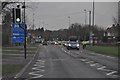
Bristol : Bromley Heath Road
Bromley Heath Road leading to Bromley Heath Roundabout.
Image: © Lewis Clarke
Taken: 1 Feb 2013
0.03 miles
2
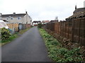
An older remnant of Bromley Heath Road
This little piece of road is still part of Bromley Heath Road and contains some older houses (behind the photographer) which have been surrounded by later development. All of them share the same street number as two houses on the main road, and they are distinguished from one another by a suffixed letter. Another remnant of the area as it was, is the drystone wall seen here.
Image: © HelenK
Taken: 19 Mar 2020
0.07 miles
3
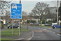
Bristol : Bromley Heath Road
Bromley Heath Road with a 2+ passenger lane.
Image: © Lewis Clarke
Taken: 1 Feb 2013
0.09 miles
4
Tollhouse by Cleeve Wood Road, Mangotsfield
Tollhouse in the parish of Kingswood (South Gloucestershire District), Turnpike Cottage (Cleeve Wood Lodge), Cleeve Wood Road, BS16.
Grade II listed.
List Entry Number: 1320078 https://historicengland.org.uk/listing/the-list/list-entry/1320078
Surveyed
Milestone Society National ID: AV.KIN01
Image: © Milestone Society
Taken: Unknown
0.22 miles
5
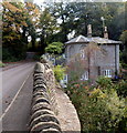
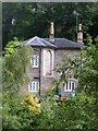
Cleeve Lodge near Frenchay
Located in the valley of the River Frome, the base of the house is below the level of Cleeve Wood Road.
Image: © Jaggery
Taken: 18 Oct 2012
0.23 miles
6
Downend, river bridge
Looking across River Frome towards Frenchay.
Image: © Mike Faherty
Taken: 29 Oct 2010
0.23 miles
7
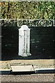
Turnpike boundary marker on Frenchay Bridge
Image: © Adrian Allsop
Taken: 30 May 2010
0.24 miles
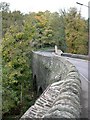
8
Frenchay: the six ton limit
This notice, dating from the glory days of Chipping Sodbury Rural District Council, is affixed to the old stone bridge across the River at Frenchay village. The bridge itself dates from 1788.
Image: © C P Smith
Taken: 27 Aug 2010
0.24 miles
9
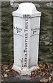
Old Boundary Marker by Cleeve Road, Frenchay, Kingswood parish
Parish Boundary Marker - Turnpike by the UC road, in parish of Kingswood (South Gloucestershire District), Cleeve Road, Frenchay, on bridge over River Frome, against parapet, South side of road.
Inscription reads:-
: MANOR / PH : : 1823 / BRISTOL TURNPIKE TRUST : : WINTER / PH :
Grade II listed.
List Entry Number: 1321087 https://historicengland.org.uk/listing/the-list/list-entry/1321087
Surveyed
Milestone Society National ID: GL_BAFY12pb
Image: © Mike Faherty
Taken: 29 Oct 2010
0.25 miles
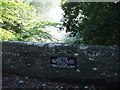
10
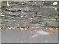
Ordnance Survey Cut Mark
This OS cut mark can be found on the north parapet of Cleeve Wood Road Bridge. It marks a point 33.220m above mean sea level.
Image: © Adrian Dust
Taken: 30 Nov 2022
0.25 miles