IMAGES TAKEN NEAR TO
Bromley Heath Road, BRISTOL, BS16 6HX
Introduction
This page details the photographs taken nearby to Bromley Heath Road, BS16 6HX by members of the Geograph project.
The Geograph project started in 2005 with the aim of publishing, organising and preserving representative images for every square kilometre of Great Britain, Ireland and the Isle of Man.

There are currently over 7.5m images from over14,400 individuals and you can help contribute to the project by visiting https://www.geograph.org.uk
Image Map (Loading...)


Getting Data...Please wait
Leaflet Map data © OpenStreetMap
Images are licensed for reuse under creativecommons.org/licenses/by-sa/2.0
Notes
- Clicking on the map will re-center to the selected point.
- The higher the marker number, the further away the image location is from the centre of the postcode.
Image Listing (10 Images Found)
Images are licensed for reuse under creativecommons.org/licenses/by-sa/2.0
Image
Details
Distance
1
Bristol : Mangotsfield - Cleeve Wood Road
From the junction with Bromley Heath Road looking up Cleeve Wood Road.
Image: © Lewis Clarke
Taken: 1 Feb 2013
0.08 miles
2
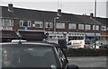
Bristol : Bromley Heath Road
Looking across to shops on Bromley Heath Road at the junction with Cleeve Hill.
Image: © Lewis Clarke
Taken: 1 Feb 2013
0.09 miles
3
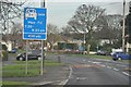
Bristol : Overndale Road
Overndale Road in Bristol at the junction with Cleeve Road.
Image: © Lewis Clarke
Taken: 1 Feb 2013
0.12 miles
4
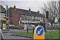
Bristol : Bromley Heath Road
Bromley Heath Road with a 2+ passenger lane.
Image: © Lewis Clarke
Taken: 1 Feb 2013
0.17 miles
5
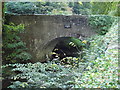
Frenchay Bridge
Built by private subscription in 1788 to replace the ford across the River Frome.
Image: © Don Ford
Taken: 17 Oct 2005
0.18 miles
6
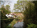
River Frome at Frenchay
The River Frome flows for 18 miles to join the Avon in the centre of Bristol. It powered a number of mills along its length.
Image: © Don Ford
Taken: 28 Apr 2006
0.18 miles
7
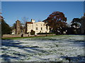
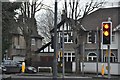
Unitarian Chapel & the Old House Frenchay
17th century Unitarian chapel with The Old House on Frenchay Common.
Image: © Don Ford
Taken: 25 Nov 2005
0.18 miles
8
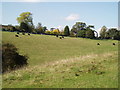
Frenchay Common
Frenchay Common is part owned by the National Trust and is a beautiful open space with fine trees and good grazing land.
Image: © Don Ford
Taken: 17 Oct 2005
0.18 miles
9
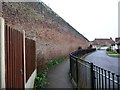
The Great Wall of Clevehill
According to the 6 inch OS map published in 1886, this was the northern boundary of the Clevehill estate. Now it forms the back garden wall of houses in Oakdale Court.
Image: © Christine Johnstone
Taken: 31 Mar 2018
0.18 miles
10
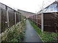
Public footpath to Oakdale Court
With the 'Great Wall of Clevehill' ahead.
Image: © Christine Johnstone
Taken: 31 Mar 2018
0.20 miles