IMAGES TAKEN NEAR TO
Oakdale Close, BRISTOL, BS16 6EF
Introduction
This page details the photographs taken nearby to Oakdale Close, BS16 6EF by members of the Geograph project.
The Geograph project started in 2005 with the aim of publishing, organising and preserving representative images for every square kilometre of Great Britain, Ireland and the Isle of Man.

There are currently over 7.5m images from over14,400 individuals and you can help contribute to the project by visiting https://www.geograph.org.uk
Image Map
Images are licensed for reuse under creativecommons.org/licenses/by-sa/2.0
Notes
- Clicking on the map will re-center to the selected point.
- The higher the marker number, the further away the image location is from the centre of the postcode.
Image Listing (7 Images Found)
Images are licensed for reuse under creativecommons.org/licenses/by-sa/2.0
Image
Details
Distance
1
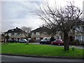
Grassed area, Oakdale Close, Downend
A little suburban oasis
Image: © Christine Johnstone
Taken: 3 Apr 2010
0.11 miles
2
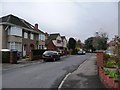
Oakdale Close, Downend
Looking to the southern junction of this road with Oakdale Road
Image: © Christine Johnstone
Taken: 3 Apr 2010
0.11 miles
3
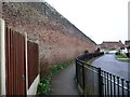
The Great Wall of Clevehill
According to the 6 inch OS map published in 1886, this was the northern boundary of the Clevehill estate. Now it forms the back garden wall of houses in Oakdale Court.
Image: © Christine Johnstone
Taken: 31 Mar 2018
0.17 miles
4
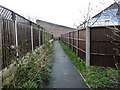
Public footpath to Oakdale Court
With the 'Great Wall of Clevehill' ahead.
Image: © Christine Johnstone
Taken: 31 Mar 2018
0.18 miles
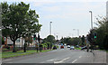
5
Bristol : Bromley Heath Road
Bromley Heath Road with a 2+ passenger lane.
Image: © Lewis Clarke
Taken: 1 Feb 2013
0.21 miles
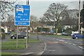
6
2011 : A432 Badminton Road entering Downend
With pedestrian crossing.
The extra lane directs traffic into Westbourne Road.
Image: © Maurice Pullin
Taken: 2 Aug 2011
0.22 miles
7
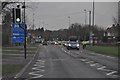
Bristol : Bromley Heath Road
Bromley Heath Road leading to Bromley Heath Roundabout.
Image: © Lewis Clarke
Taken: 1 Feb 2013
0.24 miles