IMAGES TAKEN NEAR TO
Pendennis Avenue, BRISTOL, BS16 5DW
Introduction
This page details the photographs taken nearby to Pendennis Avenue, BS16 5DW by members of the Geograph project.
The Geograph project started in 2005 with the aim of publishing, organising and preserving representative images for every square kilometre of Great Britain, Ireland and the Isle of Man.

There are currently over 7.5m images from over14,400 individuals and you can help contribute to the project by visiting https://www.geograph.org.uk
Image Map
Images are licensed for reuse under creativecommons.org/licenses/by-sa/2.0
Notes
- Clicking on the map will re-center to the selected point.
- The higher the marker number, the further away the image location is from the centre of the postcode.
Image Listing (36 Images Found)
Images are licensed for reuse under creativecommons.org/licenses/by-sa/2.0
Image
Details
Distance
1
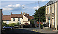
2011 : Pendennis Road, Staple Hill, Bristol
Looking north. A veterinary centre is to the left along Pendennis Avenue.
Mostly older properties here, some re-roofed.
Image: © Maurice Pullin
Taken: 19 Aug 2011
0.02 miles
2
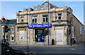
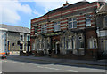
2011 : The Sanctuary Church, Staple Hill
Where the shadows of Fred and Ginger once flitted across the silver screen, the Marx Brothers went west and Frankenstein's monster terrorised the villagers.
"Staple Hill Picture House/Regal, 1912-1963
In 1905, Frank Wren, a builder who lived at The Limes in Downend, purchased the land on which the cinema stands.The cinema, known as the Staple Hill Picture House, was built in 1912. In 1913,Wren leased the land to his son, Herbert F.Wren. By 1914, Frank had died and Herbert had purchased the nearby Clematis House (now called Riebeck House) and Bank House, built around 1847.
In 1927, the cinema was extended and much altered. Bank House was incorporated into the building, as was the old gospel hall, built around 1900, that stood behind. A dome was removed from the roof and the area beneath became a cafe. The cinema, now called the Regal, reopened on Monday 29 August 1927 with the silent film Mademoiselle From Armentieres."
The above was copied from http://www.flickr.com/photos/brizzlebornandbred/4735060009/ where there is more.
In 1963 the Regal, driven by television, became a Bingo Hall, then in 1992, driven this time driven by market forces, the Bingo Hall closed in its turn.
Glad the old place is being put to good use again.
Image: © Maurice Pullin
Taken: 2 Sep 2011
0.06 miles
3
God's House on the corner
It used to be the Regal Cinema, as hinted by the grand doorway.
Opening in 1913 as the Picture House, it seated 450 and was designed by S. Loxton. It was renovated in 1927 with a new façade built and the auditorium increased to seat over 1,100. The name also changed to Regal. However, as with many provincial cinemas, the projectors stopped in 1963, inly to be taken over as a bingo hall. Even the players dwindled and the site closed in 1992. After a long period of silence, the place became a church.
Image: © Neil Owen
Taken: 24 Jan 2023
0.06 miles
4
The Old Mail House
Formerly known as the Post Office Tavern it was a well known live music venue until the previous landlord closed up following Lockdown. However, it appears to be open again.
Image: © Neil Owen
Taken: 24 Jan 2023
0.06 miles
5
2011 : Old Mail House, High Street, Staple Hill, Bristol
On the corner of High Street and Acacia Road.
Image: © Maurice Pullin
Taken: 2 Sep 2011
0.06 miles
6
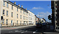
2011 : B4465 High Street, Staple Hill, Bristol
Looking east, Staple Hill's shopping centre lies ahead then the road continues to Mangotsfield.
At the junction with Acacia Road to the right and Pendennis Road to the left.
Image: © Maurice Pullin
Taken: 2 Sep 2011
0.07 miles
7
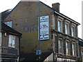
Ghostly letters on Staple Hill High Street
A painted advert (or perhaps two) on a wall is still there after so long, but the actual words are beginning to fade to the point of obscurity.
Image: © Neil Owen
Taken: 24 Jan 2023
0.08 miles
8
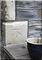
Benchmark on #28 Overnhill Road
Ordnance Survey cut mark benchmark described on the Bench Mark Database at http://www.bench-marks.org.uk/bm48031
Image: © Roger Templeman
Taken: 9 Apr 2013
0.08 miles
9
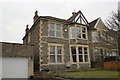
#28 Overnhill Road
There is an OS benchmark Image on the front face of the bottom corner stone at the top of the steps
Image: © Roger Templeman
Taken: 9 Apr 2013
0.08 miles
10
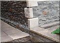
Ordnance Survey Cut Mark
This OS cut mark can be found on No28 Overhill Road. It marks a point 72.488m above mean sea level.
Image: © Adrian Dust
Taken: 28 Jul 2022
0.08 miles