IMAGES TAKEN NEAR TO
Irving Close, BRISTOL, BS16 4TE
Introduction
This page details the photographs taken nearby to Irving Close, BS16 4TE by members of the Geograph project.
The Geograph project started in 2005 with the aim of publishing, organising and preserving representative images for every square kilometre of Great Britain, Ireland and the Isle of Man.

There are currently over 7.5m images from over14,400 individuals and you can help contribute to the project by visiting https://www.geograph.org.uk
Image Map
Images are licensed for reuse under creativecommons.org/licenses/by-sa/2.0
Notes
- Clicking on the map will re-center to the selected point.
- The higher the marker number, the further away the image location is from the centre of the postcode.
Image Listing (29 Images Found)
Images are licensed for reuse under creativecommons.org/licenses/by-sa/2.0
Image
Details
Distance
2
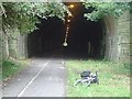
Eastern entrance to Staple Hill Tunnel, Bristol
From the Bristol-Bath cycle path. The tunnel remains open daily until dusk. Happily, trains no longer run to interfere with walkers and cyclists but constant lighting is needed to make the tunnel safe to navigate.
Image: © Anthony O'Neil
Taken: 12 May 2009
0.08 miles
3
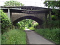
Teewell Hill Bridge
Teewell Hill crosses the former Bristol and Gloucester railway, now a cycle path.
Image: © Andy Stone
Taken: 25 Jun 2012
0.17 miles
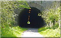
5
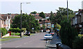
2011 : A4175 down Teewell Hill, Staple Hill
A disused railway bridge at the bottom crosses the disused Midland Railway line out of Bristol to Mangotsfield - now a cycleway.
Image: © Maurice Pullin
Taken: 2 Aug 2011
0.17 miles
6
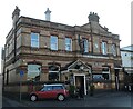
Billy Four
The pub on Broad Street, Staple Hill, dates back to the early 1900s.
Image: © Neil Owen
Taken: 24 Jan 2023
0.17 miles
7
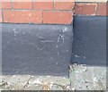
Ordnance Survey Cut Mark
This OS cut mark can be found on The King William IV PH. It marks a point 87.337m above mean sea level.
Image: © Adrian Dust
Taken: 19 Jul 2021
0.17 miles
8
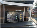
A place for boxes
A parcel distribution locker stands outside Tesco's in downtown Staple Hill - one of a growing number of public access units.
Image: © Neil Owen
Taken: 24 Jan 2023
0.17 miles
9
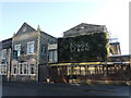
The Forge and Fern
For many years since before the turn of the 1900s, this pub on the main road was the Red Lion. It closed a couple of years ago and has then found a new build has occupied the former car park beside it. All the structure to the left is original, the green wall and glass panelling are very much the new stuff.
Image: © Neil Owen
Taken: 24 Jan 2023
0.17 miles
10
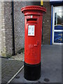
Broad Street box
A George V letterbox stands amongst the modern shops and houses on Broad Street. Cast by Carron.
Image: © Neil Owen
Taken: 24 Jan 2023
0.18 miles