IMAGES TAKEN NEAR TO
New Station Road, BRISTOL, BS16 3RS
Introduction
This page details the photographs taken nearby to New Station Road, BS16 3RS by members of the Geograph project.
The Geograph project started in 2005 with the aim of publishing, organising and preserving representative images for every square kilometre of Great Britain, Ireland and the Isle of Man.

There are currently over 7.5m images from over14,400 individuals and you can help contribute to the project by visiting https://www.geograph.org.uk
Image Map
Images are licensed for reuse under creativecommons.org/licenses/by-sa/2.0
Notes
- Clicking on the map will re-center to the selected point.
- The higher the marker number, the further away the image location is from the centre of the postcode.
Image Listing (55 Images Found)
Images are licensed for reuse under creativecommons.org/licenses/by-sa/2.0
Image
Details
Distance
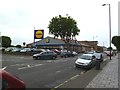
1
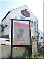
Fishponds wants you!
A familiar face with a new message: pop into the Railway Tavern!
Image: © Neil Owen
Taken: 3 Apr 2023
0.06 miles
2
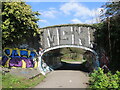
Filwood Road bridge
Now the old railway line has been ripped up, the line is a popular cycle path. It is also popular with the sprayers. Fishponds station used to be just behind the shot until its demolition.
Image: © Neil Owen
Taken: 3 Apr 2023
0.08 miles
3
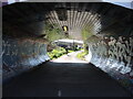
Cyclists passing under Filwood Road bridge
Formerly the site of Fishponds Station, the route is now a busy cycle path.
Image: © Neil Owen
Taken: 3 Apr 2023
0.08 miles
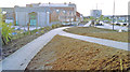
4
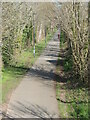
A new path by New Station Way
The old Bristol and Birmingham branch of the Midland Railway ran through north Bristol in the past but was taken out of service. However, it has now become the Bristol and Bath cyclepath.
Image: © Neil Owen
Taken: 3 Apr 2023
0.08 miles
5
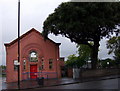
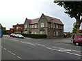
Fishponds Library
Salmon-pink - in Fishponds Road!
Image: © Natasha Ceridwen de Chroustchoff
Taken: 24 Sep 2007
0.09 miles
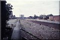
6
Site of former Fishponds station, 1992
View westward, towards Bristol Temple Meads: ex-Midland Bristol - Birmingham main line. The station was closed 7/3/66 along with the section of the main line from Bristol Temple Meads East through Mangotsfield to Yate South Junction; subsequently all trains to Gloucester and the North have used the ex-GWR route through Filton Junction and Bristol Parkway. (Cf. The 1972 image at Image], when some remains of the station were still left).
Image: © Ben Brooksbank
Taken: 24 Oct 1992
0.09 miles
9
Fishponds, former police station
On Fishponds Road; now residential.
Image: © Mike Faherty
Taken: 22 Jul 2011
0.12 miles
10
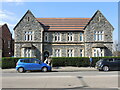
The old cop shop in Fishponds Road
The old Police Station has been on duty on the main road since the nineteenth century, but closed in the 1970s. It now is a residence.
Image: © Neil Owen
Taken: 3 Apr 2023
0.13 miles