IMAGES TAKEN NEAR TO
Lodge Causeway, BRISTOL, BS16 3JY
Introduction
This page details the photographs taken nearby to Lodge Causeway, BS16 3JY by members of the Geograph project.
The Geograph project started in 2005 with the aim of publishing, organising and preserving representative images for every square kilometre of Great Britain, Ireland and the Isle of Man.

There are currently over 7.5m images from over14,400 individuals and you can help contribute to the project by visiting https://www.geograph.org.uk
Image Map (Loading...)


Getting Data...Please wait
Leaflet Map data © OpenStreetMap
Images are licensed for reuse under creativecommons.org/licenses/by-sa/2.0
Notes
- Clicking on the map will re-center to the selected point.
- The higher the marker number, the further away the image location is from the centre of the postcode.
Image Listing (16 Images Found)
Images are licensed for reuse under creativecommons.org/licenses/by-sa/2.0
Image
Details
Distance
1
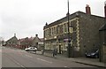
The Spotted Cow, Lodge Causeway
Just 100 yards up the road (the B4048) from Image The car is about to turn out of Ridgeway Road. Beyond are Chester Park Junior and Infant Schools, followed by St John's Church.
Image: © Derek Harper
Taken: 31 Mar 2012
0.04 miles
2
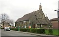
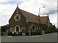
St John's Church, Lodge Causeway
Seen across the B4048 and visible on the left of Image This is one of three CofE churches in the Fishponds area. The church was consecrated in 1911.
Image: © Derek Harper
Taken: 31 Mar 2012
0.05 miles
3
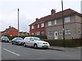
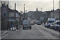
Houses in Ridgeway Rd
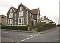
Ridgeway is a long bending residential road that climbs from its junction with Fishponds Rd the A432 in Upper Eastville to its junction with the B4048 Lodge Causeway at the western edge of Ridgeway district. This area has large numbers of red brick terraced and semidetached houses.
Image: © Nigel Mykura
Taken: 23 Feb 2013
0.09 miles
4
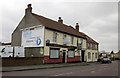
The Greyhound, Lodge Causeway
The pub lease is for sale. Its chances of survival are probably limited by the proximity of The Spotted Cow, only about 100 metres away.
Image: © Derek Harper
Taken: 31 Mar 2012
0.12 miles
5
Fishponds, Bristol, St Joseph's Catholic Church
http://www.churchcrawler.pwp.blueyonder.co.uk/bristol2/fishjose.htm
Image: © ChurchCrawler
Taken: Unknown
0.18 miles
7
Bristol : Lodge Causeway B4048
Lodge Causeway near Stapleton in Bristol.
Image: © Lewis Clarke
Taken: 1 Feb 2013
0.19 miles
8
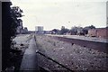
Site of former Fishponds station, 1992
View westward, towards Bristol Temple Meads: ex-Midland Bristol - Birmingham main line. The station was closed 7/3/66 along with the section of the main line from Bristol Temple Meads East through Mangotsfield to Yate South Junction; subsequently all trains to Gloucester and the North have used the ex-GWR route through Filton Junction and Bristol Parkway. (Cf. The 1972 image at Image], when some remains of the station were still left).
Image: © Ben Brooksbank
Taken: 24 Oct 1992
0.19 miles
9
House in Mayfield Park
At the corner of Mayfield Park North (left). Beyond is more modern housing.
Image: © Derek Harper
Taken: 31 Mar 2012
0.20 miles
10
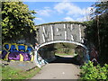
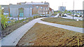
Filwood Road bridge
Now the old railway line has been ripped up, the line is a popular cycle path. It is also popular with the sprayers. Fishponds station used to be just behind the shot until its demolition.
Image: © Neil Owen
Taken: 3 Apr 2023
0.20 miles