IMAGES TAKEN NEAR TO
Riverside Drive, BRISTOL, BS16 2QZ
Introduction
This page details the photographs taken nearby to Riverside Drive, BS16 2QZ by members of the Geograph project.
The Geograph project started in 2005 with the aim of publishing, organising and preserving representative images for every square kilometre of Great Britain, Ireland and the Isle of Man.

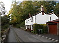
There are currently over 7.5m images from over14,400 individuals and you can help contribute to the project by visiting https://www.geograph.org.uk
Image Map
Images are licensed for reuse under creativecommons.org/licenses/by-sa/2.0
Notes
- Clicking on the map will re-center to the selected point.
- The higher the marker number, the further away the image location is from the centre of the postcode.
Image Listing (73 Images Found)
Images are licensed for reuse under creativecommons.org/licenses/by-sa/2.0
Image
Details
Distance
1
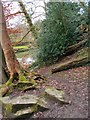
Frome Valley
Entering Lincombe Woods
Image: © norman griffin
Taken: 25 Jan 2015
0.01 miles
2
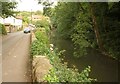
River Frome at Frenchay
Upstream from Frenchay Hill just east of Frenchay Bridge.
Image: © Derek Harper
Taken: 7 Sep 2013
0.03 miles
3
Fallen branch across the River Frome, Frenchay
Viewed from Frenchay Bridge. http://www.geograph.org.uk/photo/3977833
Image: © Jaggery
Taken: 18 Oct 2012
0.03 miles
4
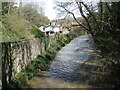
Upstream from Frenchay Bridge
The River Frome with some recent accumulation. Just along the road is the former flock mill.
Image: © Neil Owen
Taken: 13 Apr 2023
0.03 miles
5
Grove Cottage, Frenchay
Alongside Frenchay Hill, on the north bank of the River Frome.
Image: © Jaggery
Taken: 18 Oct 2012
0.04 miles
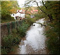
6
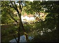
River Frome at Frenchay
The river seen just upstream from Frenchay Bridge. The cottages are on Frenchay Hill.
Image: © Derek Harper
Taken: 7 Sep 2013
0.04 miles
7
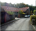
Frenchay Mill House, Frenchay
On the north bank of the River Frome, viewed across Frenchay Hill.
Image: © Jaggery
Taken: 18 Oct 2012
0.04 miles
8
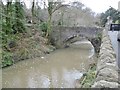
Frenchay Bridge
Carrying Frenchay Hill / Frenchay Road over River Frome. There is a plaque dating the bridge to 1788; also bollards preventing vehicles. The bridge is listed by Historic England (Grade II): https://historicengland.org.uk/listing/the-list/list-entry/1276727
Image: © Mike Faherty
Taken: 17 Mar 2018
0.04 miles
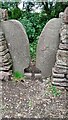
9
Stone Stile, Mangotsfield
Off Frenchay Rd at the blocked end. This stile is not on a registered footpath but looks to provide access to a leisure walk alongside the Bristol Frome. The view is Eastwards to the road, the view looking in is Image
Image: © Richard Laycock
Taken: 13 Jul 2021
0.05 miles
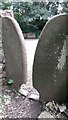
10
Stone Stile, Mangotsfield
Off Frenchay Rd at the blocked end. This stile is not on a registered footpath but looks to provide access to a leisure walk alongside the Bristol Frome. The view is from the road, the view looking out is Image
Image: © Richard Laycock
Taken: 13 Jul 2021
0.05 miles