IMAGES TAKEN NEAR TO
Pye Corner, BRISTOL, BS16 1SQ
Introduction
This page details the photographs taken nearby to Pye Corner, BS16 1SQ by members of the Geograph project.
The Geograph project started in 2005 with the aim of publishing, organising and preserving representative images for every square kilometre of Great Britain, Ireland and the Isle of Man.

There are currently over 7.5m images from over14,400 individuals and you can help contribute to the project by visiting https://www.geograph.org.uk
Image Map
Images are licensed for reuse under creativecommons.org/licenses/by-sa/2.0
Notes
- Clicking on the map will re-center to the selected point.
- The higher the marker number, the further away the image location is from the centre of the postcode.
Image Listing (10 Images Found)
Images are licensed for reuse under creativecommons.org/licenses/by-sa/2.0
Image
Details
Distance
1
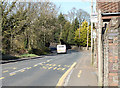
2011 : B4058 Bristol Road at the top of Whiteshill
Heading north through Winterbourne and Frampton Cotterell.
Image: © Maurice Pullin
Taken: 20 Mar 2011
0.04 miles
3
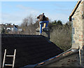
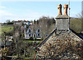
2011 : Now then my lad, if you are Father Christmas where are your reindeer?
Chimney repairs at Pye Corner.
The gentleman concerned said he did not mind the photo, don't know what he thinks of the title.
Image: © Maurice Pullin
Taken: 20 Mar 2011
0.10 miles
4
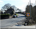
2011 : B4058 from Pye Corner
Heading south to Hambrook, Frenchay and Bristol.
Round the next bend then down to Whiteshill.
Image: © Maurice Pullin
Taken: 20 Mar 2011
0.12 miles
5
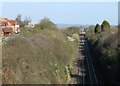
2011 : Railway to South Wales from Paddington
Looking west along the line built by the GWR to make a more direct route between Paddington and South Wales. Leaving the main line south of Wootton Bassett it avoids the loop south via Bath and Bristol. The line from Wootton Bassett is cuttings, embankments and tunnels all the way making it very expensive to build. Then there is the Severn Tunnel!
Image: © Maurice Pullin
Taken: 20 Mar 2011
0.13 miles
6
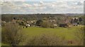
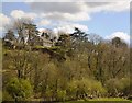
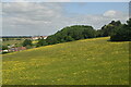
2011 : Over the chimneytops at Pye Corner
A companion picture to Image]
Seen from the B4058 Bristol Road. Looking toward Brook Farm.
The Bradley Brook is at the bottom, just out of sight.
Image: © Maurice Pullin
Taken: 20 Mar 2011
0.14 miles
7
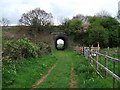
The Forgotten Road - Pye Corner
Railway Bridge at Pye Corner> Winterbourne Church spire visible through the arch.
Image: © Steve Coffin
Taken: 15 Apr 2011
0.20 miles
10
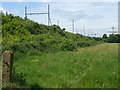
Powering the people
Part of the electrified section of the main Bristol-Bath railway, close to more electricity than a train would need.
Image: © Neil Owen
Taken: 25 May 2019
0.24 miles