IMAGES TAKEN NEAR TO
Old Gloucester Road, BRISTOL, BS16 1QW
Introduction
This page details the photographs taken nearby to Old Gloucester Road, BS16 1QW by members of the Geograph project.
The Geograph project started in 2005 with the aim of publishing, organising and preserving representative images for every square kilometre of Great Britain, Ireland and the Isle of Man.

There are currently over 7.5m images from over14,400 individuals and you can help contribute to the project by visiting https://www.geograph.org.uk
Image Map (41 Images)


Leaflet Map data © OpenStreetMap
Images are licensed for reuse under creativecommons.org/licenses/by-sa/2.0
Notes
- Clicking on the map will re-center to the selected point.
- The higher the marker number, the further away the image location is from the centre of the postcode.
Image Listing (41 Images Found)
Images are licensed for reuse under creativecommons.org/licenses/by-sa/2.0
Image
Details
Distance
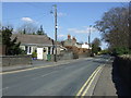
1
Frenchay Christmas Tree Farm
Presumably gearing up for its busy season, this plantation is situated in Frenchay, north Bristol. The van just visible in the trees above the right hand gatepost is travelling south on the M32 towards Bristol centre.
Image: © Phil Williams
Taken: 17 Nov 2005
0.02 miles
2
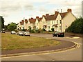
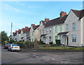
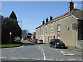
Houses on Old Gloucester Road
Looking across the junction with Filton Road to three terraces of three dwellings.
Image: © Derek Harper
Taken: 7 Sep 2013
0.03 miles
3
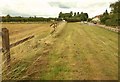
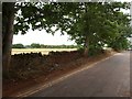
Wide verge, Old Gloucester Road
Obviously not wide enough for whatever smashed the fence on the left. Presumably its width is purely as a visibility splay for traffic turning out from Filton Road, the left turn up ahead. That is quite a busy road, leading under the M32 to Bristol Business Park and UWE's main campus. It's also used by NCN16, hence the sign you might just make out in the centre.
Image: © Derek Harper
Taken: 7 Sep 2013
0.04 miles
4
Old Gloucester Road houses, Frenchay
Viewed from the corner of Lynton Way.
Image: © Jaggery
Taken: 18 Oct 2012
0.06 miles
5
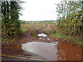
Large muddy puddle at a field entrance, Frenchay
Viewed from Old Gloucester Road.
Image: © Jaggery
Taken: 18 Oct 2012
0.09 miles
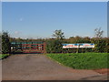
6
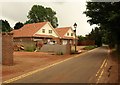
New houses on the Old Gloucester Road
A large bungalow (ironically named "The New Bungalow") has been replaced by these two even newer chalet bungalows on the lane between Filton Road and Frenchay hospital.
Image: © Derek Harper
Taken: 7 Sep 2013
0.10 miles
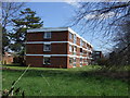
8
Old Gloucester Road
Now quite a busy lane because of a link to a bridge beneath the M32 (just visible across the fields to the left), this no longer links to Hambrook, and it must be a very long time since it was the main road to Gloucester, as what is now the B4058 to the east appears as a major road on the oldest OS maps I can trace. The light is rather unpleasant; it was sunny but is overcast with white cloud.
Image: © Derek Harper
Taken: 7 Sep 2013
0.11 miles