IMAGES TAKEN NEAR TO
Frenchay Hill, BRISTOL, BS16 1LU
Introduction
This page details the photographs taken nearby to Frenchay Hill, BS16 1LU by members of the Geograph project.
The Geograph project started in 2005 with the aim of publishing, organising and preserving representative images for every square kilometre of Great Britain, Ireland and the Isle of Man.

There are currently over 7.5m images from over14,400 individuals and you can help contribute to the project by visiting https://www.geograph.org.uk
Image Map (Loading...)


Getting Data...Please wait
Leaflet Map data © OpenStreetMap
Images are licensed for reuse under creativecommons.org/licenses/by-sa/2.0
Notes
- Clicking on the map will re-center to the selected point.
- The higher the marker number, the further away the image location is from the centre of the postcode.
Image Listing (83 Images Found)
Images are licensed for reuse under creativecommons.org/licenses/by-sa/2.0
Image
Details
Distance
1
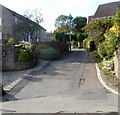
Tuckett Lane, Frenchay
A 40 metre long cul-de-sac on the west side of Frenchay Hill.
Image: © Jaggery
Taken: 18 Oct 2012
0.03 miles
2
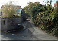
Quarry Road, Frenchay
Quarry Road climbs away from Frenchay Hill.
Image: © Jaggery
Taken: 18 Oct 2012
0.05 miles
3
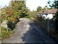
Private road in Frenchay
Viewed from Frenchay Hill. The private road leads to Rose Cottage, The Shrubbery, Hornbeam House, Larkrise and Orchard House.
Image: © Jaggery
Taken: 18 Oct 2012
0.05 miles
4
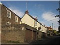
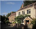
Frenchay Hill
Cottages on the steep lane up from the Frome valley.
Image: © Derek Harper
Taken: 25 Sep 2014
0.08 miles
5
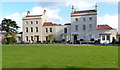
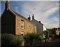
Georgian houses at the edge of Frenchay Common
Part of the Frenchay Conservation Area, which contains several 18th and early 19th century buildings.
Image: © Jaggery
Taken: 18 Oct 2012
0.09 miles
6
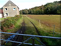
Frome Valley Walkway, Frenchay
The track heads away from Frenchay Hill towards the River Frome.
Image: © Jaggery
Taken: 18 Oct 2012
0.10 miles
7
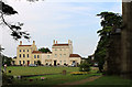
2011 : North east corner of Frenchay Common
With a corner of St.John the Baptist Church.
The fine houses in the background are on a private drive off Beckspool Road.
Image: © Maurice Pullin
Taken: 2 Aug 2011
0.11 miles
8
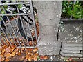
Ordnance Survey Cut Mark
This OS cut mark can be found on the gatepost of Clarendon House, Blackpool Road. It marks a point 49.862m above mean sea level.
Image: © Adrian Dust
Taken: 30 Nov 2022
0.11 miles
9
Cottages at Frenchay
Opposite Frenchay Mill and the River Frome at the foot of Frenchay Hill.
Image: © Derek Harper
Taken: 25 Sep 2014
0.12 miles
10
Cottages at Frenchay
The cottages are shown from the other direction in Image
Image: © Derek Harper
Taken: 25 Sep 2014
0.12 miles