IMAGES TAKEN NEAR TO
Park Road, BRISTOL, BS16 1AY
Introduction
This page details the photographs taken nearby to Park Road, BS16 1AY by members of the Geograph project.
The Geograph project started in 2005 with the aim of publishing, organising and preserving representative images for every square kilometre of Great Britain, Ireland and the Isle of Man.

There are currently over 7.5m images from over14,400 individuals and you can help contribute to the project by visiting https://www.geograph.org.uk
Image Map
Images are licensed for reuse under creativecommons.org/licenses/by-sa/2.0
Notes
- Clicking on the map will re-center to the selected point.
- The higher the marker number, the further away the image location is from the centre of the postcode.
Image Listing (74 Images Found)
Images are licensed for reuse under creativecommons.org/licenses/by-sa/2.0
Image
Details
Distance
1
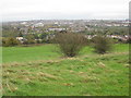
On Pur Down, looking SE over the M32 to Stapleton & Fishponds
Image: © Dr Duncan Pepper
Taken: 26 Oct 2008
0.02 miles
2
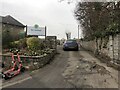
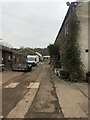
Entrance to Elm Tree Farm
The farm is a private social enterprise and Care Farm, providing support and training to adults with learning disabilities and autism, and is a part of Brandon Trust, a learning disability charity.
Near the entrance are some Voi e-scooters, these cost £1 to unlock via the Voi app and then are charged at 20p per minute to ride. While private e-scooters are banned from use on roads, pavements, parks and any other areas, the e-scooters that are hired can be used legally on roads, cycle lanes or cycle tracks.
Image: © Eirian Evans
Taken: 21 Jan 2022
0.04 miles
3
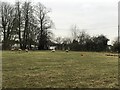
Sheep grazing at Elm Tree Farm
Elm Tree Farm is a private social enterprise and Care Farm, providing support and training to adults with learning disabilities and autism, and is a part of Brandon Trust, a learning disability charity.
Image: © Eirian Evans
Taken: 21 Jan 2022
0.09 miles
4
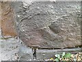
Ordnance Survey Cut Mark
This damaged OS cut mark can be found on the wall SE side of Park Road. It marks a point 38.749m above mean sea level.
Image: © Adrian Dust
Taken: 27 Jul 2022
0.10 miles
5
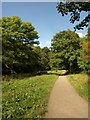
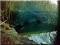
Frome Valley Walkway near Wickham Bridge
The Walkway follows footpath BCC/236/10 along a meadow upstream from the bridge.
Image: © Derek Harper
Taken: 7 Sep 2013
0.12 miles
6
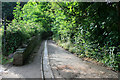
Wickham Glen
A lane in Wickham Glen!
The listing of the nearby Wickham Bridge http://list.english-heritage.org.uk/resultsingle.aspx?uid=1282028 states that it is on the original road to Gloucester from Bristol, so the route of the lane probably dates back to at least the medieval period.
Image: © David Lally
Taken: 5 Aug 2011
0.12 miles
9
Wickham Bridge Stapleton
Connects Eastville Park to Oldbury Court Estate
Image: © norman griffin
Taken: 25 Jan 2003
0.13 miles
10
Farm buildings at Elm Tree Farm
The farm is a private social enterprise and Care Farm, providing support and training to adults with learning disabilities and autism, and is a part of Brandon Trust, a learning disability charity. It has a farm shop open to the public.
Image: © Eirian Evans
Taken: 21 Jan 2022
0.13 miles