IMAGES TAKEN NEAR TO
Barton Walk, BRISTOL, BS16 1AB
Introduction
This page details the photographs taken nearby to Barton Walk, BS16 1AB by members of the Geograph project.
The Geograph project started in 2005 with the aim of publishing, organising and preserving representative images for every square kilometre of Great Britain, Ireland and the Isle of Man.

There are currently over 7.5m images from over14,400 individuals and you can help contribute to the project by visiting https://www.geograph.org.uk
Image Map
Images are licensed for reuse under creativecommons.org/licenses/by-sa/2.0
Notes
- Clicking on the map will re-center to the selected point.
- The higher the marker number, the further away the image location is from the centre of the postcode.
Image Listing (45 Images Found)
Images are licensed for reuse under creativecommons.org/licenses/by-sa/2.0
Image
Details
Distance
1
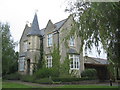
The Farmhouse at Stanley Farm
After lying derelict for many years, the farmhouse at Stanley Farm was restored as part of the MOD development at Abbey Wood. It now forms part of a training/conference facility.The main syndicate rooms are in the converted stable block which are off to the left (in the adjacent square)
Image: © Phil Williams
Taken: 30 Sep 2005
0.05 miles
3
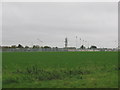
Playing fields
A view looking due south across the playing fields and sports pitches of Lockleaze school. The Bristol telecoms tower at ST610764 can be seen in the background
Image: © Phil Williams
Taken: 10 Nov 2005
0.08 miles
4
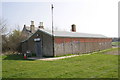
Ashley Down Old Boys RFC hut
Part of a Stanley Farm building is visible above the Rugby Football Club building.
Image: © Roger Templeman
Taken: 24 Mar 2012
0.08 miles
5
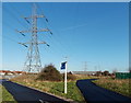
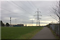
Pylon near a path junction, Concorde Way, Horfield, Bristol
Located near playing fields between Horfield and Lockleaze.
Image: © Jaggery
Taken: 29 Dec 2013
0.12 miles
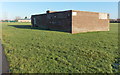
6
Dings Crusaders Community Sports Club, Bristol
Located at the northern end of Landseer Avenue, at the entrance to Dings Crusaders RFC (rugby football club).
Image: © Jaggery
Taken: 29 Dec 2013
0.13 miles
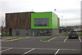
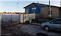
8
Bishopston RFC changing rooms block, Bristol
Located at the western edge of Bonnington Walk playing fields.
Image: © Jaggery
Taken: 29 Dec 2013
0.15 miles
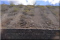
10
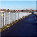
Beware trains notice alongside Concorde Way, Filton
The yellow notice on a railway perimeter fence is presumably aimed at would-be trespassers, rather than warning law-abiding walkers and cyclists to beware of trains crossing this path! The sturdy metal fence has nasty curved spikes http://www.geograph.org.uk/photo/3795955 so only the most foolhardy would-be trespasser would attempt to transgress here, in which case a small notice is hardly likely to make much difference...
Image: © Jaggery
Taken: 29 Dec 2013
0.17 miles