IMAGES TAKEN NEAR TO
Unity Street, BRISTOL, BS1 5HH
Introduction
This page details the photographs taken nearby to Unity Street, BS1 5HH by members of the Geograph project.
The Geograph project started in 2005 with the aim of publishing, organising and preserving representative images for every square kilometre of Great Britain, Ireland and the Isle of Man.

There are currently over 7.5m images from over14,400 individuals and you can help contribute to the project by visiting https://www.geograph.org.uk
Image Map
Images are licensed for reuse under creativecommons.org/licenses/by-sa/2.0
Notes
- Clicking on the map will re-center to the selected point.
- The higher the marker number, the further away the image location is from the centre of the postcode.
Image Listing (1703 Images Found)
Images are licensed for reuse under creativecommons.org/licenses/by-sa/2.0
Image
Details
Distance
1
Sundial on the Lord Mayor's Chapel
Part of St Mark's church, on College Green, which all that remains of St Mark’s Hospital, founded c.1220 to feed 100 of the city’s poor. They were to be given one meal a day of pottage and bread. By the 15th century it was more like a monastery than a charity and therefore closed by Henry VIII in 1539 along with all the other monasteries. The Corporation of Bristol purchased it from the Crown.
The photograph was taken at 2.15pm so the sundial is displaying the correct time.
Image: © Natasha Ceridwen de Chroustchoff
Taken: 12 Apr 2008
0.01 miles
2
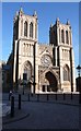
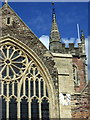
Bristol Cathedral
This is Church of England. Bristol also has a Catholic Cathedral in Clifton which is a modern building made of re-inforced concrete.
Image: © Anthony O'Neil
Taken: 26 Sep 2009
0.01 miles
3
Bristol Cathedral - from a new square at the Harbourside
Image: © Anthony O'Neil
Taken: 26 Sep 2009
0.01 miles
5
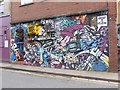
Street art on Frogmore Street
Bristol is famous for its street art. Frogmore Street passes under Park Street at a lower level.
Image: © Oliver Dixon
Taken: 11 Mar 2017
0.02 miles
6
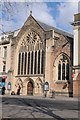
The Church of St Mark's
The Church of St Mark's overlooking College Green in Bristol.
Image: © Philip Halling
Taken: 28 Feb 2018
0.02 miles
8
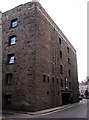
Harvey's Warehouse
This was the Harvey's Sherry warehouse in Denmark Street.
Image: © Linda Bailey
Taken: 19 Sep 2006
0.02 miles
9
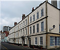
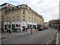
25-29 Orchard Street, Bristol
A good Georgian group, though Pevsner laments the brick being painted white. Brick is generally better revealed than concealed. The houses are delineated by rusticated stone pilaster strips. Built 1718-22. Grade II* listed.
Image: © Stephen Richards
Taken: 20 May 2012
0.03 miles
10
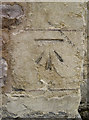
Benchmark on the Lord Mayor's Chapel, Bristol
A cut mark (as listed in the Benchmark Database - http://www.bench-marks.org.uk/bm33690 ) on the left side of the Lord Mayor's Chapel. For a detailed history try this site - http://www.about-bristol.co.uk/chu-10.asp.
Image: © Neil Owen
Taken: 8 Jun 2011
0.03 miles