IMAGES TAKEN NEAR TO
Hollyguest Road, BRISTOL, BS15 9NN
Introduction
This page details the photographs taken nearby to Hollyguest Road, BS15 9NN by members of the Geograph project.
The Geograph project started in 2005 with the aim of publishing, organising and preserving representative images for every square kilometre of Great Britain, Ireland and the Isle of Man.

There are currently over 7.5m images from over14,400 individuals and you can help contribute to the project by visiting https://www.geograph.org.uk
Image Map
Images are licensed for reuse under creativecommons.org/licenses/by-sa/2.0
Notes
- Clicking on the map will re-center to the selected point.
- The higher the marker number, the further away the image location is from the centre of the postcode.
Image Listing (34 Images Found)
Images are licensed for reuse under creativecommons.org/licenses/by-sa/2.0
Image
Details
Distance
1
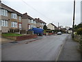
Hollyguest Road, Mount Hill
Looking east.
Image: © Christine Johnstone
Taken: 23 Mar 2013
0.03 miles
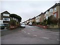
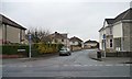
2
Tyler Close, Mount Hill
A development of detached houses below [and south of] Hollyguest Road.
Image: © Christine Johnstone
Taken: 23 Mar 2013
0.05 miles
3
Kelston Grove, Mount Hill
Looking west from Hollyguest Road.
Image: © Christine Johnstone
Taken: 23 Mar 2013
0.05 miles
4
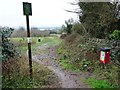
Entrance to Cock Road Ridge Open Space
On the south side of Hollyguest Road.
Image: © Christine Johnstone
Taken: 23 Mar 2013
0.07 miles
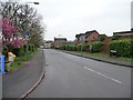
5
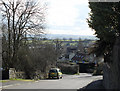
2011 : Hollyguest Road, Mount Hill, Hanham
To the south of Mount Hill Road.
The view beyond is over the Avon Valley to farmland between Keynsham and Stockwood.
Image: © Maurice Pullin
Taken: 14 Feb 2011
0.08 miles
6
Granny's Lane
Looking south from the 102 metre spot height on Mount Hill Road.
Image: © Christine Johnstone
Taken: 23 Mar 2013
0.08 miles
7
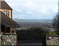
2011 : South on Hollyguest Road, Hanham
The hill falls away quickly here into the Avon Valley with Keynsham beyond.
Image: © Maurice Pullin
Taken: 14 Feb 2011
0.08 miles
8
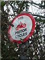
Red motorbikes prohibited
A traffic sign at the Hollyguest Road end of Luggers Hill stops two-wheelers. However, the vehicle is red, not the official black of the present legislation. Is this an unofficial sign or one from a forgotten era?
See Image] for a better example at the end of the lane.
Image: © Neil Owen
Taken: 23 Feb 2021
0.08 miles
9
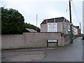
Back garden ripe for development, Mount Hill Road
A house for sale with planning permission for three new homes in the garden.
Image: © Christine Johnstone
Taken: 23 Mar 2013
0.08 miles
10
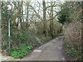
The lane after Hollyguest Road
A small lane leads to the park, but prohibits motorcycles. See Image] for a closer look at the unusual sign.
Image: © Neil Owen
Taken: 23 Feb 2021
0.09 miles