IMAGES TAKEN NEAR TO
Hanham Road, BRISTOL, BS15 8PH
Introduction
This page details the photographs taken nearby to Hanham Road, BS15 8PH by members of the Geograph project.
The Geograph project started in 2005 with the aim of publishing, organising and preserving representative images for every square kilometre of Great Britain, Ireland and the Isle of Man.

There are currently over 7.5m images from over14,400 individuals and you can help contribute to the project by visiting https://www.geograph.org.uk
Image Map
Images are licensed for reuse under creativecommons.org/licenses/by-sa/2.0
Notes
- Clicking on the map will re-center to the selected point.
- The higher the marker number, the further away the image location is from the centre of the postcode.
Image Listing (66 Images Found)
Images are licensed for reuse under creativecommons.org/licenses/by-sa/2.0
Image
Details
Distance
1
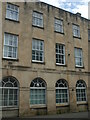
Kingswood old Post Office
This fine building served until a new distribution facility was built just a little way down Hanham Road.
Image: © Neil Owen
Taken: 29 May 2024
0.01 miles
2
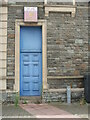
Door to the club
A side entrance/exit to the old club in the heart of Kingswood has a certain air of ageing about it. The sign above has a suitable patina and refers to the time when it was the British Legion club.
Image: © Neil Owen
Taken: 29 May 2024
0.02 miles
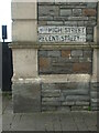
3
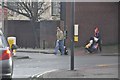
Kingswood : Cecil Road
Cecil Road at a pedestrian crossing on the junction with Regent Street and High Street.
Image: © Lewis Clarke
Taken: 1 Feb 2013
0.02 miles
5
Benchmark on the end of the High Street
At the corner of two of Kingswood's principal roads is the social club, which bears a cutmark at the base. See https://www.bench-marks.org.uk/bm84827 for the entry in the Benchmark Database.
Image: © Neil Owen
Taken: 29 May 2024
0.02 miles
6
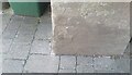
Ordnance Survey Cut Mark
This OS cut mark can be found on the club south side of Regent Street. It marks a point 112.570m above mean sea level.
Image: © Adrian Dust
Taken: 19 Jul 2021
0.02 miles
7
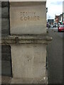
Penny Corner
On the corner of the club is a fairly neat but not obviously official engraving. Below the string course is another record of 'Penny Corner' but which is altogether much more casual.
Image: © Neil Owen
Taken: 29 May 2024
0.02 miles
8
Congregational church, Kingswood
The church, accompanied by a hall on the left, is at the junction of Hanham Road and Cecil Road.
Image: © Derek Harper
Taken: 26 Mar 2010
0.03 miles
9
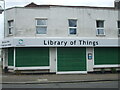
Library of Things
For many years this store was left unused after being a Spar and then a Co-op pharmacy. Now it appears to have been given a fresh chance as a Library of Things - where people can borrow useful items such as tools for projects around the home and garden, kit for adventures and parties and more.
The organisation, Share Bristol, started out as a not-for-profit Community Interest Company, but in November 2023 became a registered charity. It opened another branch in Bedminster in May, 2024.
Image: © Neil Owen
Taken: 29 May 2024
0.03 miles
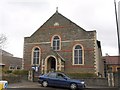
10
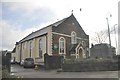
Kingswood : Kingswood Congregational Church
The church on Hanham Road in Kingswood.
Image: © Lewis Clarke
Taken: 1 Feb 2013
0.03 miles