IMAGES TAKEN NEAR TO
Moravian Road, BRISTOL, BS15 8LY
Introduction
This page details the photographs taken nearby to Moravian Road, BS15 8LY by members of the Geograph project.
The Geograph project started in 2005 with the aim of publishing, organising and preserving representative images for every square kilometre of Great Britain, Ireland and the Isle of Man.

There are currently over 7.5m images from over14,400 individuals and you can help contribute to the project by visiting https://www.geograph.org.uk
Image Map
Images are licensed for reuse under creativecommons.org/licenses/by-sa/2.0
Notes
- Clicking on the map will re-center to the selected point.
- The higher the marker number, the further away the image location is from the centre of the postcode.
Image Listing (61 Images Found)
Images are licensed for reuse under creativecommons.org/licenses/by-sa/2.0
Image
Details
Distance
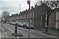
1
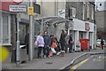
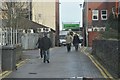
Kingswood : Moravian Road Bus Stop
People waiting at the bus stop for one to arrive any time soon.
Image: © Lewis Clarke
Taken: 1 Feb 2013
0.02 miles
3
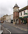
Clock Tower, Kingswood
The three-storey tower on Regent Street was built in 1897 for Queen Victoria's diamond jubilee, and looks thoroughly distinctive with its red brick central stage and lipped slate roof with dormers, a curious mix of the classical and gothic http://www.heritagegateway.org.uk/Gateway/Results_Single.aspx?uid=MSG7278&resourceID=1007 .
Image: © Derek Harper
Taken: 26 Mar 2010
0.03 miles
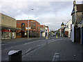
4
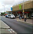
Kingswood : Regent Street A420
In the town centre of Kingswood with the clock showing us it's 10:45am.
Image: © Lewis Clarke
Taken: 1 Feb 2013
0.04 miles
5
Kingswood : Halls Road
A small road heading towards Regent Street in Kingswood.
Image: © Lewis Clarke
Taken: 1 Feb 2013
0.04 miles
6
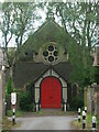
Kingswood United Church
Like others on the main road in Kingswood, this church is set back and approached by a short pathway. It remains encircled by businesses and houses, but was originally a Moravian Chapel. One of the first Protestant factions that was officially recognised, the church found lots of support in this predominantly working class area - mainly colliers. Along with Methodism, which has the Whitfield Tabernacle just up the road, the various new approaches to worship eventually combined.
Image: © Neil Owen
Taken: 29 May 2024
0.04 miles
7
Kingswood : The Co-Operative
The Co-Operative on Halls Road in Kingswood.
Image: © Lewis Clarke
Taken: 1 Feb 2013
0.06 miles
8
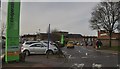
2009 : Shopping centre, Regent Street, Kingswood
The history of King's Wood dates back to Saxon times as a royal forest.
- o OO o -
"A Barbarous And Ungovernable People - A Short History Of The Miners Of The Kingswood Forest"
Read more about it in: http://www.brh.org.uk/publications.html#p11
"In the 18th century Kingswood was a small coal mining village where George Whitefield's open-air preaching greatly influenced John Wesley in the founding of Methodism."
The above was copied from: http://www.thisisbristol.co.uk/kingswood/Aardman-help-animate-Kingswood-history/article-1296592-detail/article.html
Image: © Maurice Pullin
Taken: 12 Oct 2009
0.06 miles
9
Kingswood : Cecil Road A420
Cecil Road as seen from the junction with Halls Road in Kingswood.
Image: © Lewis Clarke
Taken: 1 Feb 2013
0.06 miles
10
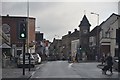
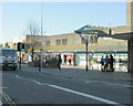
Regent Street Kingswood, looking east past the clock
In Regent Street (on the A420) in Kingswood. Looking east past Kingswood's
elegant clock tower while standing on the opposite side of the road from
the King's Chase Shopping Centre. The right-turn in the foreground is into
Moravian Road.
Image: © Colin S Pearson
Taken: 23 Oct 2005
0.07 miles