IMAGES TAKEN NEAR TO
High Street, BRISTOL, BS15 4FH
Introduction
This page details the photographs taken nearby to High Street, BS15 4FH by members of the Geograph project.
The Geograph project started in 2005 with the aim of publishing, organising and preserving representative images for every square kilometre of Great Britain, Ireland and the Isle of Man.

There are currently over 7.5m images from over14,400 individuals and you can help contribute to the project by visiting https://www.geograph.org.uk
Image Map (Loading...)


Getting Data...Please wait
Leaflet Map data © OpenStreetMap
Images are licensed for reuse under creativecommons.org/licenses/by-sa/2.0
Notes
- Clicking on the map will re-center to the selected point.
- The higher the marker number, the further away the image location is from the centre of the postcode.
Image Listing (66 Images Found)
Images are licensed for reuse under creativecommons.org/licenses/by-sa/2.0
Image
Details
Distance
1
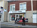
Nursery & Baby shop, on Hanham Road, Kingswood
Image: © Eirian Evans
Taken: 16 Feb 2011
0.01 miles
2
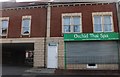
Orchid Thai Spa on High Street, Kingswood
Image: © David Howard
Taken: 1 Jun 2019
0.01 miles
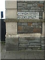
3
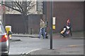
Kingswood : Cecil Road
Cecil Road at a pedestrian crossing on the junction with Regent Street and High Street.
Image: © Lewis Clarke
Taken: 1 Feb 2013
0.04 miles
4
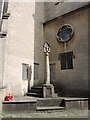
War memorial, Holy Trinity church
This cross is situated at the north-western end of the 1819 church and records the many names of parishioners who fell in the great conflicts. There are 166 names from the First, another 65 in the Second; a single addition of a Gunner Burgess has been an extra entry. Grade II listed.
Image: © Neil Owen
Taken: 4 Jul 2024
0.05 miles
5
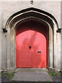
West door of Holy Trinity
A well-studded door to the 'Waterloo' church in Kingswood.
Image: © Neil Owen
Taken: 4 Jul 2024
0.05 miles
6
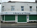
Library of Things
For many years this store was left unused after being a Spar and then a Co-op pharmacy. Now it appears to have been given a fresh chance as a Library of Things - where people can borrow useful items such as tools for projects around the home and garden, kit for adventures and parties and more.
The organisation, Share Bristol, started out as a not-for-profit Community Interest Company, but in November 2023 became a registered charity. It opened another branch in Bedminster in May, 2024.
Image: © Neil Owen
Taken: 29 May 2024
0.05 miles
7
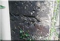
Ordnance Survey Cut Mark
This damaged OS cut mark can be found on a buttress of Holy Trinity Church. It marks a point 108.829m above mean sea level.
Image: © Adrian Dust
Taken: 19 Jul 2021
0.05 miles
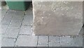
8
Benchmark on the end of the High Street
At the corner of two of Kingswood's principal roads is the social club, which bears a cutmark at the base. See https://www.bench-marks.org.uk/bm84827 for the entry in the Benchmark Database.
Image: © Neil Owen
Taken: 29 May 2024
0.05 miles
9
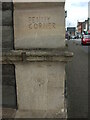
Penny Corner
On the corner of the club is a fairly neat but not obviously official engraving. Below the string course is another record of 'Penny Corner' but which is altogether much more casual.
Image: © Neil Owen
Taken: 29 May 2024
0.05 miles
10
Ordnance Survey Cut Mark
This OS cut mark can be found on the club south side of Regent Street. It marks a point 112.570m above mean sea level.
Image: © Adrian Dust
Taken: 19 Jul 2021
0.05 miles