IMAGES TAKEN NEAR TO
Chipperfield Drive, BRISTOL, BS15 4DS
Introduction
This page details the photographs taken nearby to Chipperfield Drive, BS15 4DS by members of the Geograph project.
The Geograph project started in 2005 with the aim of publishing, organising and preserving representative images for every square kilometre of Great Britain, Ireland and the Isle of Man.

There are currently over 7.5m images from over14,400 individuals and you can help contribute to the project by visiting https://www.geograph.org.uk
Image Map
Images are licensed for reuse under creativecommons.org/licenses/by-sa/2.0
Notes
- Clicking on the map will re-center to the selected point.
- The higher the marker number, the further away the image location is from the centre of the postcode.
Image Listing (7 Images Found)
Images are licensed for reuse under creativecommons.org/licenses/by-sa/2.0
Image
Details
Distance
1
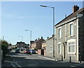
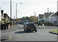
2009 : Cheltenham Road looking west
Entering New Cheltenham.
The house on the far right has a plaque dating it to 1899. The remaining dwellings date to the 1960/70's.
Image: © Maurice Pullin
Taken: 12 Oct 2009
0.12 miles
2
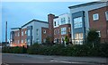
Falcon Court on New Cheltenham Road
It looks very industrial but is probably a lot nicer inside
Image: © David Howard
Taken: 1 Jun 2019
0.17 miles
3
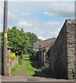
Path to Felicity Park
From Anchor Road, and running past Image] on the left.
Image: © Derek Harper
Taken: 29 May 2015
0.22 miles
4
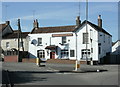
2009 : Anchor Made for Ever, New Cheltenham
Well, for the time being anyway.
Was unsure if they were still open but they are on a real ale website.
"250-year old two-bar pub, rumoured to have a residential ghost. Name came from
coal miners who thought they would be 'made forever' financially. Bass direct
from the cellar in summer."
The above was copied from:http://www.cauchy.demon.co.uk/raig/guide/ZKINGSWO.HTM
Image: © Maurice Pullin
Taken: 12 Oct 2009
0.22 miles
5
2009 : Tenniscourt Road, New Cheltenham
Leads to the A420 near the bottom of Warmley Hill.
Image: © Maurice Pullin
Taken: 12 Oct 2009
0.22 miles
6
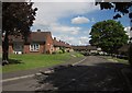
The Haven, Kingswood
On the other side of Lees Hill from Image, this is a rectangle of sheltered housing.
Image: © Derek Harper
Taken: 29 May 2015
0.23 miles
7
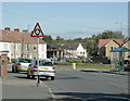
2009 : Roundabout at the end of Cheltenham Road
The eastern end, that is. New Cheltenham gives way to Siston Common on the other side of the roundabout as Cheltenham Road becomes Fisher Road.
Anchor Road is to the left and Tenniscourt Road to the right. Both of these roads were named after public houses (or vice versa).
Image: © Maurice Pullin
Taken: 12 Oct 2009
0.25 miles