IMAGES TAKEN NEAR TO
Gays Road, BRISTOL, BS15 3JS
Introduction
This page details the photographs taken nearby to Gays Road, BS15 3JS by members of the Geograph project.
The Geograph project started in 2005 with the aim of publishing, organising and preserving representative images for every square kilometre of Great Britain, Ireland and the Isle of Man.

There are currently over 7.5m images from over14,400 individuals and you can help contribute to the project by visiting https://www.geograph.org.uk
Image Map
Images are licensed for reuse under creativecommons.org/licenses/by-sa/2.0
Notes
- Clicking on the map will re-center to the selected point.
- The higher the marker number, the further away the image location is from the centre of the postcode.
Image Listing (34 Images Found)
Images are licensed for reuse under creativecommons.org/licenses/by-sa/2.0
Image
Details
Distance
1
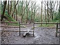
Public footpath through former quarry
Now the Avon Valley Woodlands local nature reserve.
Image: © Christine Johnstone
Taken: 23 Mar 2013
0.05 miles
2
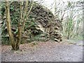
Former quarry, Avon Valley Woodlands
A working quarry until 1930. Now a local nature reserve, criss-crossed with paths.
Image: © Christine Johnstone
Taken: 23 Mar 2013
0.06 miles
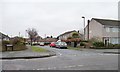
3
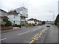
Memorial Road, near the northern end of Gays Road
The house on the junction must be getting a new roof, or a loft extension.
Image: © Christine Johnstone
Taken: 23 Mar 2013
0.09 miles
4
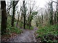
Footpath junction in Avon Valley Woodlands
The mapped public footpath drops down the valley side.
Image: © Christine Johnstone
Taken: 23 Mar 2013
0.09 miles
5
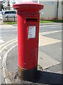
A Georgian postbox on Gays Road
Some George VI street furniture.
Image: © Neil Owen
Taken: 30 Jul 2020
0.09 miles
6
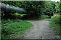
Pipeline below Conham
This pipeline I have been informed is a sewage pipe; it is exposed in a few places beside the River Avon below Conham. A footpath passes beneath it.
Image: © Philip Halling
Taken: 1 Sep 2007
0.10 miles
7
Heath Road
Looking westwards from the junction with Memorial Road.
Image: © Christine Johnstone
Taken: 23 Mar 2013
0.10 miles
8
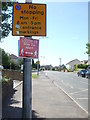
Don't stop or get too close!
Some modern and current traffic signs for users on either side of the kerb.
Image: © Neil Owen
Taken: 30 Jul 2020
0.10 miles
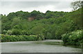
9
The other side of the Avon
Steeper woodland on that side.
Image: © Neil Owen
Taken: 17 May 2020
0.11 miles
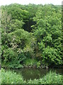
10
River Avon above Conham
View downstream towards the red cliffs at Conham
Image: © Pierre Terre
Taken: 20 May 2006
0.11 miles