IMAGES TAKEN NEAR TO
Memorial Road, BRISTOL, BS15 3JQ
Introduction
This page details the photographs taken nearby to Memorial Road, BS15 3JQ by members of the Geograph project.
The Geograph project started in 2005 with the aim of publishing, organising and preserving representative images for every square kilometre of Great Britain, Ireland and the Isle of Man.

There are currently over 7.5m images from over14,400 individuals and you can help contribute to the project by visiting https://www.geograph.org.uk
Image Map
Images are licensed for reuse under creativecommons.org/licenses/by-sa/2.0
Notes
- Clicking on the map will re-center to the selected point.
- The higher the marker number, the further away the image location is from the centre of the postcode.
Image Listing (30 Images Found)
Images are licensed for reuse under creativecommons.org/licenses/by-sa/2.0
Image
Details
Distance
1

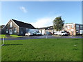
An old house in an old colliery
The former engine house of Hanham Colliery is one building that has remained after the closure. The pit originally opened in 1906 but conditions were poor and work difficult. When the General Strike of 1926 happened the pit was deemed unprofitable and closed. The area was partly redeveloped with industrial units occupying the site. However, the old winding engine house was left derelict and largely smothered by vegetation but was saved recently and is now a business.
Image: © Neil Owen
Taken: 30 Jul 2020
0.08 miles
2

Former engine house, Memorial Road
Now the home of a supplier of kitchens.
Image: © Christine Johnstone
Taken: 23 Mar 2013
0.09 miles
3

A Georgian postbox on Gays Road
Some George VI street furniture.
Image: © Neil Owen
Taken: 30 Jul 2020
0.09 miles
4
Hanham Business Park
This was the site of Hanham Colliery that closed in 1926. On the left is the house for a horizontal steam winding engine.
Image: © Chris Allen
Taken: 19 Oct 2019
0.10 miles
5
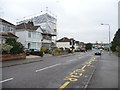
Memorial Road, near the northern end of Gays Road
The house on the junction must be getting a new roof, or a loft extension.
Image: © Christine Johnstone
Taken: 23 Mar 2013
0.11 miles
6
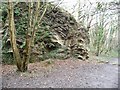
Former quarry, Avon Valley Woodlands
A working quarry until 1930. Now a local nature reserve, criss-crossed with paths.
Image: © Christine Johnstone
Taken: 23 Mar 2013
0.11 miles
7
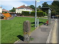
An old stone post out on its own
The familiar roadside furniture on Memorial Road also has an older stone post, typical of gateposts of the past. Perhaps this one should have been removed as there is no other to pair it with. In the not too distant past the area was fairly rural, although it is not far from the (now lost) Hanham Colliery.
Image: © Neil Owen
Taken: 30 Jul 2020
0.12 miles
8
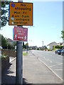
Don't stop or get too close!
Some modern and current traffic signs for users on either side of the kerb.
Image: © Neil Owen
Taken: 30 Jul 2020
0.12 miles
9
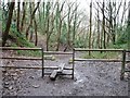
Public footpath through former quarry
Now the Avon Valley Woodlands local nature reserve.
Image: © Christine Johnstone
Taken: 23 Mar 2013
0.13 miles
10
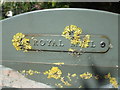
Letters and lichens
The post box cabinet on Memorial Road shows the result of being positioned under a tree. See http://www.geograph.org.uk/photo/6557671 for a wider view.
Image: © Neil Owen
Taken: 30 Jul 2020
0.14 miles