IMAGES TAKEN NEAR TO
Dean Close, BRISTOL, BS15 3HU
Introduction
This page details the photographs taken nearby to Dean Close, BS15 3HU by members of the Geograph project.
The Geograph project started in 2005 with the aim of publishing, organising and preserving representative images for every square kilometre of Great Britain, Ireland and the Isle of Man.

There are currently over 7.5m images from over14,400 individuals and you can help contribute to the project by visiting https://www.geograph.org.uk
Image Map
Images are licensed for reuse under creativecommons.org/licenses/by-sa/2.0
Notes
- Clicking on the map will re-center to the selected point.
- The higher the marker number, the further away the image location is from the centre of the postcode.
Image Listing (67 Images Found)
Images are licensed for reuse under creativecommons.org/licenses/by-sa/2.0
Image
Details
Distance
1
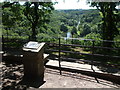
The Panorama Walk
This spot on the high cliffs overlooking the River Avon has been popular with walkers since time immemorial. However, once the old quarries closed the area has had a much more natural ambience and so the council made the path official. This is The Panorama Walk, opened on 13th April, 1957, by Mr Anthony Wedgwood Benn, M.P.
Image: © Neil Owen
Taken: 30 Jul 2020
0.05 miles
3
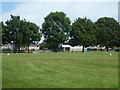
Vicarage Road playing fields
Another green space in Hanham.
Image: © Neil Owen
Taken: 30 Jul 2020
0.08 miles
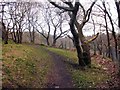
4
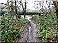
Muddy towpath on the east bank of the Avon
Part of the Monarch's Way, the Avon Walkway and the River Avon Trail.
Image: © Christine Johnstone
Taken: 23 Mar 2013
0.11 miles
5
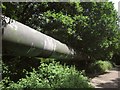
Pipe by the River Avon Trail
Another view of the pipe shown in Image There seem to be differences of opinion as to what's inside; sewage, according to Image, but "fresh water from a man made lake in Chew Valley into the city for our tap water" according to http://seebristol.blogspot.co.uk/2012/10/100-steps-to-hanham.html .
Image: © Derek Harper
Taken: 13 Jul 2013
0.11 miles
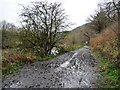
6
Sewage pipe in the Avon Valley
The public footpath drops underneath it to reach the river towpath.
Image: © Christine Johnstone
Taken: 23 Mar 2013
0.12 miles
7
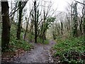
Footpath junction in Avon Valley Woodlands
The mapped public footpath drops down the valley side.
Image: © Christine Johnstone
Taken: 23 Mar 2013
0.12 miles
8
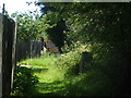
A secluded and leafy spot for a recluse
This lane at the back of Lime Road is home to a trig pillar. It is partly enclosed by the trees and grass but see Image] for a better look.
Image: © Neil Owen
Taken: 30 Jul 2020
0.12 miles
9
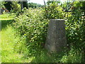
The Conham trig
This triangulation pillar lies in a fairly busy spot near the high parts of the Panoramic Walk. However, it appears not to have endured much unwelcome attention in the time. See Image] for the spider.
Image: © Neil Owen
Taken: 30 Jul 2020
0.12 miles
10
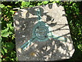
An intact top
This triangulation pillar is really close to a large population yet it seems pretty untouched - unlike many in similar places. The top of the pillar shows the spider for the theodolite and the centre cap is original - most are now lost or filled in. The three hooks were to aid installation. See Image] for the flush bracket.
Image: © Neil Owen
Taken: 30 Jul 2020
0.12 miles