IMAGES TAKEN NEAR TO
Woodyleaze Drive, BRISTOL, BS15 3BY
Introduction
This page details the photographs taken nearby to Woodyleaze Drive, BS15 3BY by members of the Geograph project.
The Geograph project started in 2005 with the aim of publishing, organising and preserving representative images for every square kilometre of Great Britain, Ireland and the Isle of Man.

There are currently over 7.5m images from over14,400 individuals and you can help contribute to the project by visiting https://www.geograph.org.uk
Image Map (Loading...)


Getting Data...Please wait
Leaflet Map data © OpenStreetMap
Images are licensed for reuse under creativecommons.org/licenses/by-sa/2.0
Notes
- Clicking on the map will re-center to the selected point.
- The higher the marker number, the further away the image location is from the centre of the postcode.
Image Listing (35 Images Found)
Images are licensed for reuse under creativecommons.org/licenses/by-sa/2.0
Image
Details
Distance
1
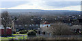
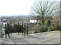
2011 : View from Mount Hill Road, Hanham
Most of Hanham is built on slopes from the River Avon up to Kingswood.
There are occasional views of south east Bristol. This is over Brislington and Stockwood with Dundry Hill in the background. In the original version it is possible to see Dundry church Image left of centre on the horizon.
Image: © Maurice Pullin
Taken: 14 Feb 2011
0.02 miles
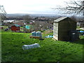
2
Allotments on the south side of Mount Hill Road
In late March, after a cold and wet winter.
Image: © Christine Johnstone
Taken: 23 Mar 2013
0.08 miles
3
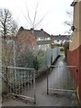
Public footpath to Birdwood
Running south from Mount Hill Road.
Image: © Christine Johnstone
Taken: 23 Mar 2013
0.09 miles
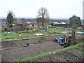
4
Mount Hill Road allotments
These slopes have been allotments since the Second World War.
Image: © Neil Owen
Taken: 23 Feb 2021
0.10 miles
5
Hanham Mount, Mount Hill Road
A display board here points out the links with evangelical preachers who had preached here.
Image: © Chris Allen
Taken: 19 Oct 2019
0.10 miles
6
Marking the source of the movement
This cross set into the ground is the Hanham Mount memorial to the founding of the Methodist movement. In the 1600s and onwards, the Baptists were considered to be an unwelcome addition to the established order and followers were persecuted. The local population was largely involved with coal mining and had a bad reputation.
But given the need to reach the people without a recognised church, John Wesley, John Cennick the Moravian and George Whitfield began to hold open air services here. The site has a number of markers to commemorate the story.
Image: © Neil Owen
Taken: 23 Feb 2021
0.11 miles
7
Woodlease Drive
Looking west from the junction with Greenbank Road.
Image: © Christine Johnstone
Taken: 23 Mar 2013
0.11 miles
8
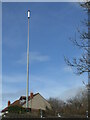
A very tall mobile communications mast in Hanham?
This tall structure stands far above the rooftops, high on Hanham Mount. It may look like a communications mast but it is 38m (80') tall and occupies a prominent position in the landscape. It is in fact the memorial beacon, dedicated to the many persecuted Baptists who lived in the more intolerant times of the seventeenth and eighteenth centuries. Close by is the site where John Wesley began his unrepentant open-air sermons to the masses, thus founding the Methodist movement.
The original beacon was built in the 1950s as part of the activities marking the Festival of Britain. It too was a very tall and somewhat spindly erection, but was later declared unsafe. This one (an even taller version) was put up in 2008. It emits a green light at night.
Image: © Neil Owen
Taken: 23 Feb 2021
0.12 miles
9
Where Wesley spoke to all
The origin of the Methodist movement is marked here on Hanham Mount. In 1739 John Wesley, along with the likes of George Whitfield and John Cennick the Moravian, held open-air services. The movement was disregarded by the establishment and prevented much of their work, particularly building a church. So Wesley preached in the open air to the many attendees, who were mainly from the coal-mining areas of Kingswood (then a separate region from Bristol).
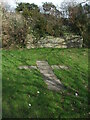
This site is given over to a memorial, which includes this space where a pulpit once stood. Here Wesley would give a sermon on The Mount.
Image: © Neil Owen
Taken: 23 Feb 2021
0.12 miles
10
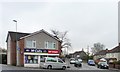
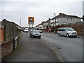
McColls corner shop
At the junction of Mount Hill and Hollyguest Roads.
Image: © Christine Johnstone
Taken: 23 Mar 2013
0.14 miles