IMAGES TAKEN NEAR TO
Syston Way, BRISTOL, BS15 1UJ
Introduction
This page details the photographs taken nearby to Syston Way, BS15 1UJ by members of the Geograph project.
The Geograph project started in 2005 with the aim of publishing, organising and preserving representative images for every square kilometre of Great Britain, Ireland and the Isle of Man.

There are currently over 7.5m images from over14,400 individuals and you can help contribute to the project by visiting https://www.geograph.org.uk
Image Map
Images are licensed for reuse under creativecommons.org/licenses/by-sa/2.0
Notes
- Clicking on the map will re-center to the selected point.
- The higher the marker number, the further away the image location is from the centre of the postcode.
Image Listing (16 Images Found)
Images are licensed for reuse under creativecommons.org/licenses/by-sa/2.0
Image
Details
Distance
2
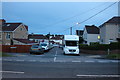
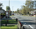
2009 : Syston Way, Hopewell Hill (2)
Cheltenham Road takes over just the other side of the bus then runs through New Cheltenham to Siston Common - that bus, coming at a fair rate, better run for it.
Image: © Maurice Pullin
Taken: 12 Oct 2009
0.06 miles
4
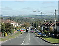
2009 : Syston Way, Hopewell Hill
Heading east, a little further down it becomes Cheltenham Road leading into New Cheltenham, a housing estate mostly built in the 1950/60's.
On the skyline to the right a line of trees marks Freezing Hill Image a prominent landmark in the area between Bath and Bristol. On the extreme right the horizon slopes up to Lansdown, which is not shown here.
Image: © Maurice Pullin
Taken: 12 Oct 2009
0.10 miles
5
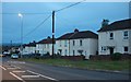
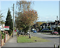
2009 : Cheltenham Road, New Cheltenham (2)
Looking west from the mini roundabouts near the shopping centre.
An attractive spot for what it is, the maturing trees do much to improve the appearance.
The planners didn't do too badly here.
Image: © Maurice Pullin
Taken: 12 Oct 2009
0.11 miles
6
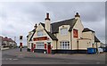
The Shant
A pub on Hopewell Hill, on the corner of Crown Road (left) and Wesley Hill.
Image: © Derek Harper
Taken: 26 Mar 2010
0.15 miles
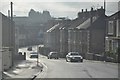
7
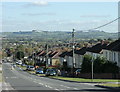
2009 : Cheltenham Road, New Cheltenham
One of the housing estates which sprang up around Bristol during the 1950's.
Don't know why they called it New Cheltenham, could have been wishful thinking.
Freezing Hill Image appears on the horizon to the right.
Image: © Maurice Pullin
Taken: 12 Oct 2009
0.16 miles
8
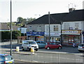
2009 : Shops, Cheltenham Road
In combination with the beautician, the Post Office and general store opposite, make up most of the New Cheltenham shopping centre.
Image: © Maurice Pullin
Taken: 12 Oct 2009
0.19 miles
9
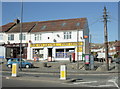
2009 : Post Office and Off Licence, New Cheltenham
News agent, confectioner, general store, etc. etc. If they can't thrive in the face of competition from the supermarkets, who can?
I've been trying to see what they do in that brown shop next door, looks like "Hair Beauty Nails".
Image: © Maurice Pullin
Taken: 12 Oct 2009
0.19 miles
10
Bristol : Downend Road A4017
Downend Road between Soundwell Road and Regent Street.
Image: © Lewis Clarke
Taken: 1 Feb 2013
0.21 miles