IMAGES TAKEN NEAR TO
Tarnock Avenue, BRISTOL, BS14 9SB
Introduction
This page details the photographs taken nearby to Tarnock Avenue, BS14 9SB by members of the Geograph project.
The Geograph project started in 2005 with the aim of publishing, organising and preserving representative images for every square kilometre of Great Britain, Ireland and the Isle of Man.

There are currently over 7.5m images from over14,400 individuals and you can help contribute to the project by visiting https://www.geograph.org.uk
Image Map
Images are licensed for reuse under creativecommons.org/licenses/by-sa/2.0
Notes
- Clicking on the map will re-center to the selected point.
- The higher the marker number, the further away the image location is from the centre of the postcode.
Image Listing (5 Images Found)
Images are licensed for reuse under creativecommons.org/licenses/by-sa/2.0
Image
Details
Distance
1
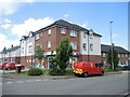
Shops on Loxton Square
The old single-storey concrete row of shops was demolished a few years ago and this much larger store and post office created. Extra space has been consumed by new houses too.
Image: © Neil Owen
Taken: 19 May 2022
0.09 miles
2
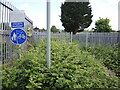
No bikes in school
An old pedestrian entrance to the old Hengrove School is now firmly fenced off. The overgrowing brambles are an extra touch to prevent egress, either on foot or wheels.
Image: © Neil Owen
Taken: 19 May 2022
0.10 miles
3
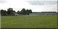
Perry Court Junior & Infant School
Seen from Great Hayles Road
Image: © Colin Bews
Taken: 2 Jul 2011
0.15 miles
4
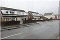
Houses on Bamfield
A wet dreary day on Bamfield. These semi detached houses are between Clydesdale Close and Maes Knoll Close.
Image: © Nigel Mykura
Taken: 25 Dec 2021
0.19 miles
5
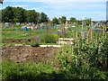
Oatlands Avenue Allotments , Hengrove
Seen from Oatlands Avenue opposite the Cartwheel pub. The houses beyond are in Loxton Square.
Image: © Derek Harper
Taken: 3 Jun 2006
0.22 miles