IMAGES TAKEN NEAR TO
Fortfield Road, BRISTOL, BS14 9NL
Introduction
This page details the photographs taken nearby to Fortfield Road, BS14 9NL by members of the Geograph project.
The Geograph project started in 2005 with the aim of publishing, organising and preserving representative images for every square kilometre of Great Britain, Ireland and the Isle of Man.

There are currently over 7.5m images from over14,400 individuals and you can help contribute to the project by visiting https://www.geograph.org.uk
Image Map (Loading...)


Getting Data...Please wait
Leaflet Map data © OpenStreetMap
Images are licensed for reuse under creativecommons.org/licenses/by-sa/2.0
Notes
- Clicking on the map will re-center to the selected point.
- The higher the marker number, the further away the image location is from the centre of the postcode.
Image Listing (19 Images Found)
Images are licensed for reuse under creativecommons.org/licenses/by-sa/2.0
Image
Details
Distance
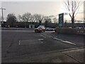
1
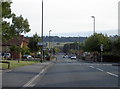
Fortfield Road, Whitchurch
The straight line of the road is aligned almost directly with Maes Knoll - an Iron Age fort on the Dundry Ridge, 1.5km to the south.
Image: © Neil Owen
Taken: 8 Aug 2010
0.02 miles
2
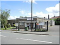
Hengrove Community Centre
The centre is on Fortfield Road and is part of the post-war development of south Bristol.
Image: © Neil Owen
Taken: 19 May 2022
0.11 miles
3
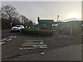
Bristol : Whitchurch - ASDA
Looking towards the petrol station.
Image: © Lewis Clarke
Taken: 21 Feb 2023
0.12 miles
4
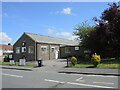
Hengrove Youth Centre
Built as part of the community centre, this end of the building offers many organised classes.
Image: © Neil Owen
Taken: 19 May 2022
0.13 miles
5
Bristol : Whitchurch - ASDA
A road heads from the main store into the petrol station.
Image: © Lewis Clarke
Taken: 21 Feb 2023
0.15 miles
6
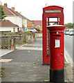
2010 : George VI postbox, Wharnecliffe Gardens
And phone box.
Image: © Maurice Pullin
Taken: 6 Sep 2010
0.17 miles
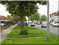
7
2010 : Wharnecliffe Gardens, Hengrove, Bristol
One of Bristol's post war developments, an improvement on those of the 1920/30's.
You can see trees!!!
Image: © Maurice Pullin
Taken: 6 Sep 2010
0.17 miles
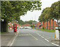
8
2010 : Wharnecliffe Gardens, Hengrove
An avenue of trees graces the north side of the road.
A development of the 1950's / 60's I believe, though some of the houses are later.
Image: © Maurice Pullin
Taken: 6 Sep 2010
0.18 miles
9
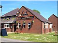
The Cartwheel, Whitchurch
Over the road, to the left of camera, is Image
Image: © Derek Harper
Taken: 3 Jun 2006
0.20 miles
10
Photoelectric Avenue #3
Gilda Square West entrance to the electric village. See Image] for more.
Image: © Neil Owen
Taken: 14 Feb 2012
0.21 miles