IMAGES TAKEN NEAR TO
Wells Road, BRISTOL, BS14 9HS
Introduction
This page details the photographs taken nearby to Wells Road, BS14 9HS by members of the Geograph project.
The Geograph project started in 2005 with the aim of publishing, organising and preserving representative images for every square kilometre of Great Britain, Ireland and the Isle of Man.

There are currently over 7.5m images from over14,400 individuals and you can help contribute to the project by visiting https://www.geograph.org.uk
Image Map
Images are licensed for reuse under creativecommons.org/licenses/by-sa/2.0
Notes
- Clicking on the map will re-center to the selected point.
- The higher the marker number, the further away the image location is from the centre of the postcode.
Image Listing (20 Images Found)
Images are licensed for reuse under creativecommons.org/licenses/by-sa/2.0
Image
Details
Distance
1
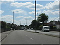
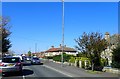
The dual carriageway Wells Road through Hengrove
Image: © Sarah Charlesworth
Taken: 16 Aug 2010
0.01 miles
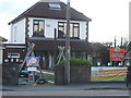
2

Posted elsewhere
This was once the Hengrove post office and local stores; due to organisational reviews, it shut its doors on Monday 26 June, 2017, and is now a private residence.
Image: © Neil Owen
Taken: 7 May 2020
0.04 miles
3
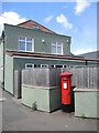
The post office is gone but the box remains
The former Lorraine Stores was the post office for many years and the George VI letterbox used to stand closer to the shopfront. However, the shop closed and is now in private hands; the letterbox was moved to its own little recess.
Image: © Neil Owen
Taken: 19 May 2022
0.05 miles
4
'Keep smiling'
A cheery sign outside the (closed for lockdown?) nursery.
Image: © Neil Owen
Taken: 7 May 2020
0.06 miles
5
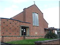
Counterslip Baptist Church
The church was founded in 1948 but the buildings were situated further to the rear. The current brick building seen here overlooking the Wells Road was a newer construction of 1957.
Image: © Neil Owen
Taken: 7 May 2020
0.07 miles
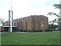
6
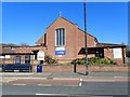
Counterslip Baptist Church, Wells Road
Counterslip Baptist Church was founded in 1804 when 49 members of the declining Pithay Church left and decided to set up a church of their own at Tailor's Court. The first service was held on 12 November of that year. By 1810 numbers at the church had risen to around 70. It was then that the church moved to Counterslip, near Bristol Bridge, and acquired the name that it is still known by today. The church moved to its present site on Wells Road in 1957.
Image: © Eirian Evans
Taken: 11 Apr 2019
0.07 miles
7
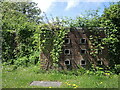
Ornate walling near the Bush Centre
Some unusual styling for a council site. At least the wildlife seem encouraged.
Image: © Neil Owen
Taken: 19 May 2022
0.09 miles
8
A former council site
Just off the Fosseway Road is a council site: part of it is the Bush Residential Resource Centre, the rest has been demolished in recent years.
Image: © Neil Owen
Taken: 19 May 2022
0.09 miles
9
Wells Road, Whitchurch
Heading towards Bristol
Image: © Eirian Evans
Taken: 11 Apr 2019
0.18 miles
10
Church of Jesus Christ of Latter-day Saints
Founded in 1966 with its distinctive structure.
Image: © Neil Owen
Taken: 7 May 2020
0.18 miles