IMAGES TAKEN NEAR TO
Bifield Road, BRISTOL, BS14 8TJ
Introduction
This page details the photographs taken nearby to Bifield Road, BS14 8TJ by members of the Geograph project.
The Geograph project started in 2005 with the aim of publishing, organising and preserving representative images for every square kilometre of Great Britain, Ireland and the Isle of Man.

There are currently over 7.5m images from over14,400 individuals and you can help contribute to the project by visiting https://www.geograph.org.uk
Image Map
Images are licensed for reuse under creativecommons.org/licenses/by-sa/2.0
Notes
- Clicking on the map will re-center to the selected point.
- The higher the marker number, the further away the image location is from the centre of the postcode.
Image Listing (9 Images Found)
Images are licensed for reuse under creativecommons.org/licenses/by-sa/2.0
Image
Details
Distance
1
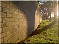
Benchmark on the garages
Found on the grey bricked garages along Stockwood Lane, opposite the junction with Hollway Road. See http://www.bench-marks.org.uk/bm39857 for the listing in the Benchmark Database, and Image] for a wider view of the late evening sunshine.
Image: © Neil Owen
Taken: 28 Oct 2011
0.10 miles
2
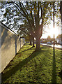
Stockwood Lane
Late evening sunshine picks out the trees and lamp-posts. A benchmark is located along the brick wall of the garages:Image
Image: © Neil Owen
Taken: 28 Oct 2011
0.10 miles
3
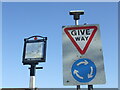
Jets give way to motors
The Concorde pub on Stockwood Lane dates from the expansion of Stockwood in the 1950/60s and takes its name from the passenger jet that was part designed and built in Bristol. Sadly, the supersonic aircraft is no longer flying and the pub sign bears the mark of time.
Image: © Neil Owen
Taken: 28 Feb 2021
0.12 miles
4
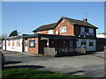
The Concorde, Stockwood
One of the pubs built at the same time as the estate, and still just about surviving in the Covid lockdown.
Image: © Neil Owen
Taken: 28 Feb 2021
0.12 miles
5
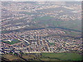
Stockwood, near Whitchurch
Housing estates to the southeast of Bristol
Image: © M J Richardson
Taken: 23 Dec 2015
0.12 miles
6
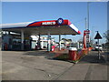
Murco Garage on Stockwood Lane
Open for fuel and a few other consumable items.
Image: © Neil Owen
Taken: 28 Feb 2021
0.14 miles
7
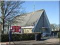
Stockwood Free Church
The Baptist church was constructed as the first of the new houses were being built, and was part of the original plans when Stockwood grew up from Sturminster Road. Despite the problems caused in the terrible winter of 1963, the church was completed and a ceremonial opening held on Saturday 7th December that year.
Image: © Neil Owen
Taken: 28 Feb 2021
0.18 miles
8
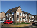
PVs on Pynne Road
The area around Pynne Road used to be the site of the Man in Space pub, but it closed in 2014 and was bulldozed. In its place is a small development of houses. Note the use of photvoltaic cells (solar panels) on each roof - albeit just a couple!
Image: © Neil Owen
Taken: 28 Feb 2021
0.21 miles
9
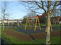
Cottle Road play area
New equipment in the park is slowly clearing the frost of a morning.
Image: © Neil Owen
Taken: 10 Jan 2021
0.24 miles