IMAGES TAKEN NEAR TO
Stockwood Road, BRISTOL, BS14 8HS
Introduction
This page details the photographs taken nearby to Stockwood Road, BS14 8HS by members of the Geograph project.
The Geograph project started in 2005 with the aim of publishing, organising and preserving representative images for every square kilometre of Great Britain, Ireland and the Isle of Man.

There are currently over 7.5m images from over14,400 individuals and you can help contribute to the project by visiting https://www.geograph.org.uk
Image Map (Loading...)


Getting Data...Please wait
Leaflet Map data © OpenStreetMap
Images are licensed for reuse under creativecommons.org/licenses/by-sa/2.0
Notes
- Clicking on the map will re-center to the selected point.
- The higher the marker number, the further away the image location is from the centre of the postcode.
Image Listing (61 Images Found)
Images are licensed for reuse under creativecommons.org/licenses/by-sa/2.0
Image
Details
Distance
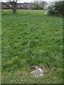
1
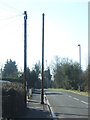
Vent pipe on Stockwood Road
The suburb was created in the 1950/60s but this vent pipe looks like it is a lot older and has been resited.
Image: © Neil Owen
Taken: 28 Feb 2021
0.01 miles
2
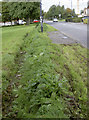
A modern defensive ditch
Whitchurch Green is a patch of open grassland at the end of Stockwood Road, which had recently been invaded by travellers. In order to deter them using the space again (and leaving lots of rubbish), the council have dug a small ditch and ramparts around the edge of the area. This sort of technique has not been seen in this part of the world since possibly the Iron Age. The ditch is about a couple of feet deep. Note the fact that the grass was recently mown by the same council. Also note the bus stop: the hardstanding area is isolated, with the only non-grass approach entailing crossing the road.
Image: © Neil Owen
Taken: 29 Sep 2017
0.02 miles
3
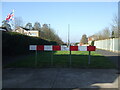
Goslet Road stops
The road stops with some rather abrupt barriers. Perhaps the original plan when the place was designed in the 1950s and 50s was to extend it to the crossroads.
Image: © Neil Owen
Taken: 28 Feb 2021
0.04 miles
4
Would a cup of tea be out of the question?
A chance to enjoy some Deity and dunkies in Christ the Servant church, Stockwood.
Image: © Neil Owen
Taken: 2 Mar 2012
0.04 miles
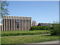
5

Making it easy
The small patch of greenery around Stockwood has been maintained for ease of use.
Image: © Neil Owen
Taken: 4 Apr 2020
0.05 miles
6
A post holder?
The small patch of green at the top of Stockwood Road was once the site of Whitchurch Green Farm over a century ago. Among the shrubs and paths are little reminders - this stone in the ground appears to have a socket in it, perhaps for a post.
Image: © Neil Owen
Taken: 4 Apr 2020
0.05 miles
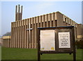
7
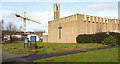
Church and crane, Stockwood
The crane appears in Image, the church of Christ the Servant in Image and Image The architect of the church (1964) was J Ralph Edwards.
Image: © Derek Harper
Taken: 10 Mar 2018
0.05 miles
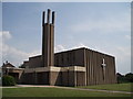
8
An unusual Easter
It's Easter Monday, 2020, but the Covid-19 lockdown means that there is no-one in the church. A Union Flag flies in the face of the impositions.
Image: © Neil Owen
Taken: 13 Apr 2020
0.05 miles
10
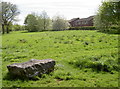
A farm now lost
This part of the old Whitchurch Green area was actually the site of Whitchurch Green Farm. It disappeared from the maps in the early 1960s, about the time that Stockwood was being created.
The boulder and small ditch/rampart are designed to prevent ingress by travellers.
Image: © Neil Owen
Taken: 26 Apr 2018
0.07 miles