IMAGES TAKEN NEAR TO
Bamfield, BRISTOL, BS14 0SA
Introduction
This page details the photographs taken nearby to Bamfield, BS14 0SA by members of the Geograph project.
The Geograph project started in 2005 with the aim of publishing, organising and preserving representative images for every square kilometre of Great Britain, Ireland and the Isle of Man.

There are currently over 7.5m images from over14,400 individuals and you can help contribute to the project by visiting https://www.geograph.org.uk
Image Map
Images are licensed for reuse under creativecommons.org/licenses/by-sa/2.0
Notes
- Clicking on the map will re-center to the selected point.
- The higher the marker number, the further away the image location is from the centre of the postcode.
Image Listing (14 Images Found)
Images are licensed for reuse under creativecommons.org/licenses/by-sa/2.0
Image
Details
Distance
1
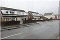
Houses on Bamfield
A wet dreary day on Bamfield. These semi detached houses are between Clydesdale Close and Maes Knoll Close.
Image: © Nigel Mykura
Taken: 25 Dec 2021
0.03 miles
2
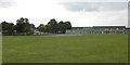
Perry Court Junior & Infant School
Seen from Great Hayles Road
Image: © Colin Bews
Taken: 2 Jul 2011
0.12 miles
3
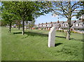
In a moon's course
This granite pillar stands at the eastern end of the old tarmac runway of Whitchurch Airport - or at least that which still exists. Founded in the 1930s as a commercial airport and later seeing war-time use, the site finally closed in 1957 and Bristol's efforts directed to the old R.A.F. station at Lulsgate Bottom - now Bristol Airport. However, a monument has been placed here as a tribute to the many men and women who helped in the Air Transport Auxiliary.
With so many men taken to fight in the war, a movement came about to train civilians to fly and transport the aircraft coming out of the factories. Distribution and logistics were part of the essential job that the A.T.A. undertook from 1939-45. Founded originally at Croydon, the A.T.A. moved to Whitchurch airfield and became No. 2 Ferry Pool, carrying out the work until the end of the war. This monument commemorates the one hundred and seventy-three people from all over the world who gave their lives in the A.T.A. - many without meeting enemy action.
The plaque ends with this line:
'Remember them that also we
in a moon's course are history.'
Image: © Neil Owen
Taken: 12 May 2015
0.13 miles
4
Looking up the runway
A monument to the A.T.A. stands at the end of what remains of the old Whitchurch Airport tarmac runway. See Image] for more details. Hengrove Sports centre and hospital are at the left of the background.
Image: © Neil Owen
Taken: 12 May 2015
0.13 miles
5
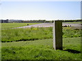
Tree of tiles
A small piece of art at a gate on the fringe of the old Whitchurch Airport lies as a 'tree of life'. The installation cost some £36,000.
Image: © Neil Owen
Taken: 12 May 2015
0.15 miles
6
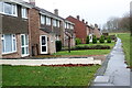
Front of Houses on Swainswick
There is no road in front of these houses whose rear backs on to Swainswick. They face a small green area that leads from Bamfield through to Hengrove Park whcich can be seen in the distance.
Image: © Nigel Mykura
Taken: 25 Dec 2021
0.16 miles
7
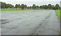
Former runway, old Whitchurch airport
See also http://www.geograph.org.uk/search.php?i=127880871 . The airport operated from 1930-1957. The housing in the background is on Rowacres.
Image: © Derek Harper
Taken: 3 Sep 2020
0.17 miles
8

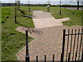
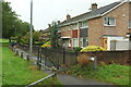
Path to Bamfield
A wall on the left encloses housing on Holcombe.
Image: © Derek Harper
Taken: 3 Sep 2020
0.18 miles
9
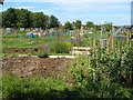
Oatlands Avenue Allotments , Hengrove
Seen from Oatlands Avenue opposite the Cartwheel pub. The houses beyond are in Loxton Square.
Image: © Derek Harper
Taken: 3 Jun 2006
0.18 miles
10
Widcombe, Hengrove
A path to Hengrove Park passes in front of a terrace of houses.
Image: © Derek Harper
Taken: 3 Sep 2020
0.20 miles