IMAGES TAKEN NEAR TO
Bristol Road, BRISTOL, BS14 0PQ
Introduction
This page details the photographs taken nearby to Bristol Road, BS14 0PQ by members of the Geograph project.
The Geograph project started in 2005 with the aim of publishing, organising and preserving representative images for every square kilometre of Great Britain, Ireland and the Isle of Man.

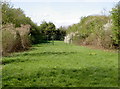
There are currently over 7.5m images from over14,400 individuals and you can help contribute to the project by visiting https://www.geograph.org.uk
Image Map
Images are licensed for reuse under creativecommons.org/licenses/by-sa/2.0
Notes
- Clicking on the map will re-center to the selected point.
- The higher the marker number, the further away the image location is from the centre of the postcode.
Image Listing (68 Images Found)
Images are licensed for reuse under creativecommons.org/licenses/by-sa/2.0
Image
Details
Distance
1
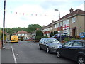
Dressing up for the VE 75 celebrations
A bit of bunting suggests that the street is going to participate in the nation's socially-distanced festivities tomorrow.
Image: © Neil Owen
Taken: 7 May 2020
0.06 miles
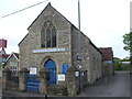
2
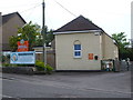
Mama Bear has moved in
This little hall is now a day nursery. Previously it was a Kingdom Hall for the Jehovah's Witnesses. In fact they took over the site which was originally a telephone exchange from the Inter-war period.
Image: © Neil Owen
Taken: 29 Apr 2020
0.07 miles
3
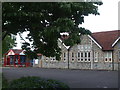
Whitchurch primary school
Schooling in the old Whitchurch village began in 1837 in the form a national school. This primary school replaced it.
Image: © Neil Owen
Taken: 29 Apr 2020
0.08 miles
4
Whitchurch telephone exchange
There used to be a smaller exchange on the opposite side of the Wells Road before this facility was built. Of course, it does not have a doorbell but a more obvious means of attracting attention.
Image: © Neil Owen
Taken: 29 Apr 2020
0.10 miles
5
A bonus of the axe
Looking north from Whitchurch along the route of the old Bristol and North Somerset railway line, it was sometwhat good fortune for some residents when the Beeching Axe arrived. This part of the track is to the rear of Whitchurch primary school, but beyond the fencing the land has become an extension of the gardens of homes along Dene Road.
Image: © Neil Owen
Taken: 26 Apr 2018
0.10 miles
6
Whitchurch U.R.C.
The church, originally a Congregational chapel founded in 1830, recalls the years when the village was well away from the sprawl of Bristol. In those days there was a much smaller population in a quiet rural setting; today it lies right on the very busy Wells Road.
Image: © Neil Owen
Taken: 29 Apr 2020
0.11 miles
7
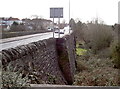
Saltwell Viaduct
The other side of the viaduct, showing the height above the stream.
Image: © Neil Owen
Taken: 14 Feb 2012
0.11 miles
8
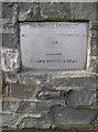
Saltwell Viaduct - Rebuilt
The large bridge that carries the main A37 Wells Road over the small stream below was extensively rebuilt. This plaque gives the details. See Image] for a look down the back.
Image: © Neil Owen
Taken: 14 Feb 2012
0.11 miles
9

Whitchurch village community hall
The hall serves the 'village' (albeit that Bristol's boundaries have now swallowed it up) and is of postwar date.
Image: © Neil Owen
Taken: 29 Apr 2020
0.11 miles
10
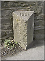
County boundary stone
It used to be the divisor between Bristol and Somerset, but now it marks the boundary of Bristol and BaNES. How times (and politics) have changed since 1951. See Image] for a more modern approach to signage.
Image: © Neil Owen
Taken: 14 Feb 2012
0.13 miles