IMAGES TAKEN NEAR TO
Church Road, BRISTOL, BS14 0PN
Introduction
This page details the photographs taken nearby to Church Road, BS14 0PN by members of the Geograph project.
The Geograph project started in 2005 with the aim of publishing, organising and preserving representative images for every square kilometre of Great Britain, Ireland and the Isle of Man.

There are currently over 7.5m images from over14,400 individuals and you can help contribute to the project by visiting https://www.geograph.org.uk
Image Map
Images are licensed for reuse under creativecommons.org/licenses/by-sa/2.0
Notes
- Clicking on the map will re-center to the selected point.
- The higher the marker number, the further away the image location is from the centre of the postcode.
Image Listing (54 Images Found)
Images are licensed for reuse under creativecommons.org/licenses/by-sa/2.0
Image
Details
Distance
1
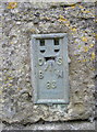
Flush Bracket, Whitchurch
A fairly uncommon example of a flush bracket, embedded in the wall of a farm building. The bracket is part of the Second Geodetic Levelling of England and Wales, dating from late 1912. It gives the height of the mark as 80.17m (263ft) above Newlyn sea level, and was last officially surveyed in 1957.
See Image] for a wider view and http://www.bench-marks.org.uk/bm2688 for the Benchmark Database.
Image: © Neil Owen
Taken: 18 Feb 2011
0.04 miles
2
Church Farm, Whitchurch
Wider view of the location of Flush Bracket number 83. See Image] for detailed view and http://www.bench-marks.org.uk/bm2688 for the Benchmark database.
Image: © Neil Owen
Taken: 18 Feb 2011
0.04 miles
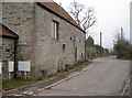
3

Old Granary, Church Farm, Whitchurch
A view from the opposite direction of the building shown in Image, along Church Road.
Image: © Derek Harper
Taken: 3 Jun 2006
0.05 miles
4
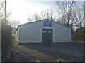
Scouts Hut on Maggs Lane
Home to the 107th Bristol (Whitchurch) group.
Image: © Neil Owen
Taken: 10 Jan 2021
0.10 miles
5
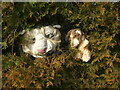
Furry faces in the hedge
Along Washing Pound Lane is a hedge with lots of teddy bears and soft toys embedded in it.
Image: © Neil Owen
Taken: 10 Jan 2021
0.10 miles
6
2009 : Old chapel in Church Road, Whitchurch
Denomination unknown. Methodism was strong in this area.
Image: © Maurice Pullin
Taken: 2 May 2009
0.10 miles
7
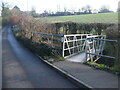
Footbridge on Maggs Lane
The alloy bridge spans the brook that joins the Brislington Brook some distance north. It also marks the boundary between the City of Bristol and BANES.
Image: © Neil Owen
Taken: 10 Jan 2021
0.11 miles
8
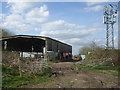
Getting a good signal
A farm has some high tech company.
Image: © Neil Owen
Taken: 4 Apr 2020
0.11 miles
9
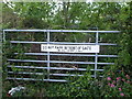
Not such a busy gate
Not one that is used frequently, anyway.
Image: © Neil Owen
Taken: 29 Apr 2020
0.12 miles
10
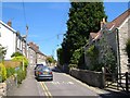
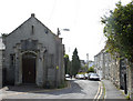
Church Road, Whitchurch
Cottages line the north side of the street. The church is further along off to the right.
Image: © Derek Harper
Taken: 3 Jun 2006
0.12 miles