IMAGES TAKEN NEAR TO
Horsepool Road, BRISTOL, BS13 8RL
Introduction
This page details the photographs taken nearby to Horsepool Road, BS13 8RL by members of the Geograph project.
The Geograph project started in 2005 with the aim of publishing, organising and preserving representative images for every square kilometre of Great Britain, Ireland and the Isle of Man.

There are currently over 7.5m images from over14,400 individuals and you can help contribute to the project by visiting https://www.geograph.org.uk
Image Map (Loading...)


Getting Data...Please wait
Leaflet Map data © OpenStreetMap
Images are licensed for reuse under creativecommons.org/licenses/by-sa/2.0
Notes
- Clicking on the map will re-center to the selected point.
- The higher the marker number, the further away the image location is from the centre of the postcode.
Image Listing (5 Images Found)
Images are licensed for reuse under creativecommons.org/licenses/by-sa/2.0
Image
Details
Distance
1
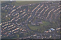
North Somerset : Bristol Suburbs
Flying above North Somerset looking down towards the Bristol suburbs with Four Acres Primary School and the surrounding residential area in view.
Image: © Lewis Clarke
Taken: 27 Aug 2014
0.08 miles
3
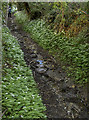
Strawberry Lane
This lane is not one that would take a motor vehicle. Indeed, it is not terribly friendly to walkers even thought the stream is gentle today. The water is part of the issues from Dundry that form the River Malago.
Image: © Neil Owen
Taken: 12 May 2016
0.16 miles
4
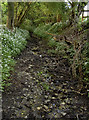
Strawberry Lane
One of the routes that the River Malago takes as the waters run down from Dundry runs through this gravelly lane.
Image: © Neil Owen
Taken: 12 May 2016
0.17 miles
5
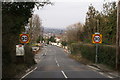
Bristol City Limits by Withywood
Image: © Adrian and Janet Quantock
Taken: 11 Mar 2006
0.24 miles